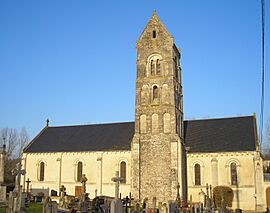
Longraye facts for kids
Quick facts for kids
Longraye
|
|
|---|---|
|
Part of Aurseulles
|
|
 |
|
| Country | France |
| Region | Normandy |
| Department | Calvados |
| Arrondissement | Bayeux |
| Canton | Les Monts d'Aunay |
| Commune | Aurseulles |
| Area
1
|
6.59 km2 (2.54 sq mi) |
| Population
(2019)
|
233 |
| • Density | 35.36/km2 (91.57/sq mi) |
| Time zone | UTC+01:00 (CET) |
| • Summer (DST) | UTC+02:00 (CEST) |
| Postal code |
14250
|
| Elevation | 68–138 m (223–453 ft) (avg. 133 m or 436 ft) |
| 1 French Land Register data, which excludes lakes, ponds, glaciers > 1 km2 (0.386 sq mi or 247 acres) and river estuaries. | |
Longraye was a small village, also known as a commune, located in northwestern France. It was part of the Calvados area in the Normandy region.
On January 1, 2017, Longraye joined with other nearby villages to form a new, larger commune called Aurseulles. This means Longraye is no longer a separate commune on its own.
How Many People Lived in Longraye?
The number of people living in Longraye changed over the years. Here's a quick look at its population:
- In 1962, there were 218 people.
- By 1968, the population grew slightly to 225.
- In 1975, it reached 236 residents.
- The population peaked in 1982 with 248 people.
- It then decreased to 237 in 1990 and 206 in 1999.
- By 2008, the population had risen again to 238 people.
The most recent count before it merged was 233 people in 2019.
See also
- In Spanish: Longraye para niños
Black History Month on Kiddle
Famous African-American Pilots:
 | Bessie Coleman |
 | Spann Watson |
 | Jill E. Brown |
 | Sherman W. White |

All content from Kiddle encyclopedia articles (including the article images and facts) can be freely used under Attribution-ShareAlike license, unless stated otherwise. Cite this article:
Longraye Facts for Kids. Kiddle Encyclopedia.


