Loomis, Michigan facts for kids
Quick facts for kids
Loomis, Michigan
|
|
|---|---|

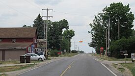
Intersection of Saginaw and Loomis Road
|
|

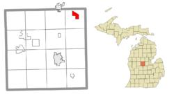
Location within Isabella County
|
|
| Country | United States |
| State | Michigan |
| County | Isabella |
| Township | Wise |
| Settled | 1871 |
| Area | |
| • Total | 2.82 sq mi (7.30 km2) |
| • Land | 2.80 sq mi (7.25 km2) |
| • Water | 0.02 sq mi (0.05 km2) |
| Elevation | 805 ft (245 m) |
| Population
(2020)
|
|
| • Total | 194 |
| • Density | 69.29/sq mi (26.75/km2) |
| Time zone | UTC-5 (Eastern (EST)) |
| • Summer (DST) | UTC-4 (EDT) |
| ZIP code(s) |
48617 (Clare)
|
| Area code(s) | 989 |
| GNIS feature ID | 631028 |
Loomis is a small community in Isabella County, Michigan, in the United States. It is an unincorporated community, meaning it doesn't have its own local government. It's also a census-designated place (CDP), which is an area defined for counting people during the census. In 2020, about 194 people lived there. Loomis is part of Wise Township and is also located within the Isabella Indian Reservation, home to the Saginaw Chippewa Tribal Nation.
History of Loomis
The Loomis community began around 1871. It was settled by Erastus Loomis, George Wise, and E. F. Gould. They built a sawmill and a general store, which helped the community grow.
In the same year, Loomis got a train station along the Flint and Pere Marquette Railroad. It also received a post office on May 1, 1871, first called Buchtel. George Wise was the first postmaster. The post office name changed to Loomis on December 8, 1871. When the area became a new township on January 24, 1872, it was named Wise Township.
Loomis grew quickly, especially during the time of the lumber and railroad industries. In 1877, about 350 people lived there. The community had several sawmills, general stores, churches, and two hotels. At its busiest, the population might have reached 800 people.
The railway served Loomis until about 1960, when the train tracks were removed. In the early 1960s, U.S. Route 10 was expanded. This new highway bypassed Loomis, meaning traffic no longer went directly through the community. This caused the community to shrink. By 1970, Loomis had only about 15 families, a gas station, a market, and the town hall.
The oldest building in Loomis is Patrick Holden's hotel. It was one of the first buildings when the community started in 1871. Today, this old hotel building is a market and antique shop.
In the 2010 census, Loomis was officially listed as a new census-designated place. It had a population of 213 people then. The Loomis post office is no longer open. The community now uses the 48617 ZIP Code from Clare.
Geography of Loomis
Loomis is a small area. According to the U.S. Census Bureau, the Loomis CDP covers about 2.82 square miles (7.30 square kilometers). Most of this area, about 2.80 square miles (7.25 square kilometers), is land. A very small part, about 0.02 square miles (0.05 square kilometers), is water.
U.S. Route 10 goes near Loomis. You can get to the community from the Loomis Road exit (exit 98). The Pere Marquette Rail-Trail, a path for walking and biking, also goes through Loomis. This trail follows the old railway line.
Loomis is also located within the boundaries of the Isabella Indian Reservation. Students in Loomis attend schools in the Clare Public Schools district, which is located in the city of Clare.
Population Data
The population of Loomis has changed over the years. Here's how many people lived there during recent censuses:
| Historical population | |||
|---|---|---|---|
| Census | Pop. | %± | |
| 2010 | 213 | — | |
| 2020 | 194 | −8.9% | |
| U.S. Decennial Census | |||
See also
 In Spanish: Loomis para niños


