Lost Creek (South Fork Little Butte Creek tributary) facts for kids
Quick facts for kids Lost Creek |
|
|---|---|

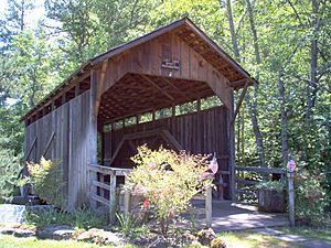
Lost Creek Bridge in 2007
|
|
|
Location of the mouth of Lost Creek in Oregon
|
|
| Country | United States |
| State | Oregon |
| County | Jackson |
| Physical characteristics | |
| Main source | Cascade Range near Lost Lake, east of Medford 4,716 ft (1,437 m) 42°17′13″N 122°31′31″W / 42.28694°N 122.52528°W |
| River mouth | South Fork Little Butte Creek near Lake Creek 1,824 ft (556 m) 42°23′11″N 122°35′04″W / 42.38639°N 122.58444°W |
| Basin features | |
| Basin size | 17.2 sq mi (45 km2) |
Lost Creek is a small stream in Jackson County, Oregon. It flows into a larger stream called the South Fork of Little Butte Creek. This creek starts near Lost Lake, east of the city of Medford.
Lost Creek: A Stream in Oregon
Lost Creek begins high up in the Cascade Range mountains. It flows north from its source near Lost Lake. The creek eventually joins the South Fork of Little Butte Creek. This meeting point is about 4 miles (6.4 km) upstream from the small town of Lake Creek. Little Butte Creek then flows into the Rogue River.
What is a Tributary?
A tributary is a smaller stream or river. It flows into a larger stream or river. Think of it like a branch joining a bigger tree trunk. Coon Creek is the only named tributary of Lost Creek. It flows into Lost Creek from the left side.
The Historic Lost Creek Bridge
The Lost Creek Bridge is a special bridge that crosses Lost Creek. It is a type of bridge called a covered bridge. This means it has a roof and sides, like a house. The bridge carries Lost Creek Road over the water.
The Lost Creek Bridge is 39 feet (12 meters) long. It is the shortest covered bridge in all of Oregon. Today, cars and trucks cannot drive over it. It is only open for people walking or biking. In 1979, the bridge was added to the National Register of Historic Places. This means it is an important historical site.
 | Aurelia Browder |
 | Nannie Helen Burroughs |
 | Michelle Alexander |


