
Little Butte Creek facts for kids
Quick facts for kids Little Butte Creek |
|
|---|---|

The north fork of Little Butte Creek
|
|

Location of the mouth of Little Butte Creek in Oregon
|
|
| Country | United States |
| State | Oregon |
| Counties | Jackson County, Klamath County |
| Physical characteristics | |
| Main source | Near Lake Creek Cascade Range, Jackson County, Oregon 1,647 ft (502 m) 42°25′11″N 122°37′08″W / 42.41972°N 122.61889°W |
| River mouth | Rogue River about 3 miles (4.8 km) southwest of Eagle Point, Jackson County, Oregon 1,204 ft (367 m) 42°27′03″N 122°52′47″W / 42.45083°N 122.87972°W |
| Length | 17 mi (27 km) |
| Basin features | |
| Basin size | 373 sq mi (970 km2) |
Little Butte Creek is a stream in Oregon, USA. It flows for about 17 miles (27 km) before joining the Rogue River. The creek's drainage basin covers about 373 square miles (966 km2) in Jackson County and Klamath County.
The creek has two main parts: the North Fork and the South Fork. Both start high up in the Cascade Range. They begin near Mount McLoughlin and Brown Mountain. The two forks meet near Lake Creek.
After the forks join, the main creek flows west. It passes through towns like Brownsboro and Eagle Point. Finally, it empties into the Rogue River. This happens about 3 miles (5 km) southwest of Eagle Point.
Long ago, Native American tribes like the Takelma lived here. Later, settlers named the creek after nearby Mount McLoughlin, which they called Snowy Butte. In the past, people used the land for farming and cutting down trees. Today, Eagle Point is the only town in the creek's area.
People use a lot of water from Little Butte Creek. It helps water farms and fills lakes like Howard Prairie Lake and Agate Lake. This water also helps make electricity.
Even with some pollution, the creek is important for fish. Many Coho and Chinook salmon swim upstream each year. Special fish ladders help them get past dams.
Contents
Where the Creek Flows
Little Butte Creek starts in the Cascade Range. It begins near Mount McLoughlin and Brown Mountain. The creek flows west for about 17 miles (27 km). It then joins the Rogue River.
The South Fork starts high up, at 5,713 feet (1,741 m) above sea level. The North Fork begins a bit lower, at 4,638 feet (1,414 m). They meet at 1,647 feet (502.0 m). The creek's end is at 1,204 feet (367.0 m) above sea level. This means the creek drops about 25 feet per mile (4.7 m/km) for every mile it flows.
The North Fork starts at Fish Lake. It flows west and gets water from smaller streams. The South Fork begins south of Brown Mountain, which is 7,311 feet (2,228 m) tall. The Pacific Crest Trail is in this area.

The South Fork gets water from Beaver Dam Creek and Dead Indian Creek. These creeks drain large areas of land. The Dead Indian Soda Springs are also on Dead Indian Creek. The South Fork then turns northwest. It collects water from Lost Creek.
The two forks join about 15 miles (24 km) northeast of Medford. Here, Little Butte Creek also gets water from Lake Creek. Water is taken from the creek here to fill Agate Lake. This water also helps irrigate farms around Medford.
Further west, Salt Creek and Lick Creek join the main stream. Oregon Route 140 crosses the creek. The creek then flows southwest through Eagle Point. Several bridges cross the creek in Eagle Point.
Near Eagle Point, Antelope Creek joins Little Butte Creek. This is the largest stream that flows into Little Butte Creek. Agate Lake is in the Antelope Creek area. Finally, Little Butte Creek flows into the Rogue River. This is near the Denman Wildlife Area.
How Much Water Flows?

The United States Geological Survey (USGS) used to measure the water flow. They had seven stations along the creek. These stations recorded how much water was flowing.
Here is some of the information they collected:
| Stream Part | Location | Area Drained | Years Measured | Average Flow | Highest Flow | Lowest Flow |
|---|---|---|---|---|---|---|
| North Fork | near its end | 52 sq mi (130 km2) | 1922–1931 | 57.0 cu ft/s (1.61 m3/s) | 1,750 cu ft/s (49.55 m3/s) (December 22, 1964) |
0 cu ft/s (0 m3/s) (many times 1922–1968) |
| South Fork | near its end | 138 sq mi (357 km2) | 1922–1982 | 97.3 cu ft/s (2.76 m3/s) | 6,280 cu ft/s (177.8 m3/s) (May 25, 1942) |
3.0 cu ft/s (0.085 m3/s) (July–August 1931) |
| Main Creek | RM 4 (RK 6.5) | 293 sq mi (759 km2) | 1908–1950 | 232.3 cu ft/s (6.578 m3/s) | 10,000 cu ft/s (280 m3/s) (January 7, 1948) |
5.8 cu ft/s (0.16 m3/s) (June 6, 1926) |
The Land Around the Creek

The land around Little Butte Creek is about 373 square miles (966 km2). The lowest point is 1,204 feet (367.0 m) at the creek's mouth. The highest point is Mount McLoughlin, at 9,495 feet (2,894 m).
Most of the land, about 65 percent, is forest. Farms cover 32 percent. The rest is part of Eagle Point town. About half of the land is owned by the government. The other half is privately owned. More than 10,000 people live in this area.
The weather here is like a Mediterranean climate. Summers are warm, around 90 °F (32 °C). Winters are cold, around 20 °F (−6.7 °C). It rains more in winter and spring. The driest months are July through October.
The area has two main types of land. The western part has steep canyons. The lower areas have soils made of old lava, clay, and gravel. The eastern part has volcanoes like Brown Mountain and Mount McLoughlin. Some streams here drop very quickly.
Plants and Animals of the Watershed

The Little Butte Creek area is mostly temperate coniferous forest. This means it has many cone-bearing trees. Lower areas have chaparral plants. Higher areas have fir forests.
In the chaparral, you can find oak trees. These include Garry oak and California black oak. Smaller plants like buckbrush also grow there. The mixed forests have Douglas-fir and ponderosa pine.
Higher up, you'll see Shasta red fir and noble fir. Near the tree line, there are whitebark pine and heather. Many different plants make this area their home.
Many kinds of birds live near Little Butte Creek. In the chaparral, you might see wrens and sparrows. The mixed forests are home to white-headed woodpeckers and northern pygmy-owls. American coots are seen along the creek.
Higher up, look for Williamson's sapsuckers and Canada jays. The near-threatened olive-sided flycatcher also lives here. The endangered Townsend's big-eared bat is found in the watershed.
Little Butte Creek is very important for salmon. It is one of the best places for salmon in the Rogue River system. Chinook and coho salmon swim up the creek to lay their eggs. Sea-run cutthroat trout also live here.
The Coho salmon in this area are considered a threatened group. In 2002, about 35,000 Coho salmon lived in the creek. Other fish like rainbow trout also live in the creek year-round.
A Glimpse into History
The Takelma and possibly the Shasta Native American tribes first lived in the Little Butte Creek area. The first non-Native American settlers arrived in 1852. They named the creek after Mount McLoughlin, which was called Snowy Butte.
In the 1850s, there were conflicts with Native American groups. In one event in 1855, many people died near the creek's mouth. More conflicts happened later that year.
By the late 1850s, people used the land for farming and cutting trees. A sawmill was built on the North Fork in the 1870s. The town of Eagle Point was officially formed in 1911. It is still the only town in the watershed.
In 1917, a mineral called manganese was found near the South Fork. Another mineral, cinnabar, was also discovered. The Antelope Creek Covered Bridge was built in 1922. It was moved to Little Butte Creek in Eagle Point in 1987.
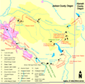
How Water is Used
Water from Little Butte Creek helps irrigate the Rogue Valley. It also adds water to Bear Creek. In the late 1800s, many fruit farms were planted near Ashland. They needed more water than Bear Creek could provide.
So, in 1898, the Fish Lake Water Company was started. They planned to make Fourmile and Fish lakes bigger. They also built canals to connect them. The Fish Lake Dam was finished in 1908.
The Cascade Canal was completed in 1915. It brought water from Fourmile Lake to Fish Lake. The Fish Lake Dam was later made stronger. It is 50 feet (15 m) high and 960 feet (293 m) long.
In 1956, the Deadwood Tunnel was built. This tunnel helps move water from the South Fork of Little Butte Creek. It sends water to Howard Prairie Lake. This helps supply water to the surrounding areas.
The Howard Prairie Delivery Canal was finished in 1959. It moves water from Howard Prairie Lake to Keene Creek Reservoir. This water then goes through the Cascade Tunnel to the Greensprings Power Plant. This plant makes about 18 megawatts of electricity.
After that, the water flows through the Greensprings Tunnel. It ends up in Emigrant Creek, which flows into Emigrant Lake. This water is then used for irrigation.
The Butte Creek Mill

The Butte Creek Mill was built in 1872. It sits on the banks of Little Butte Creek. A dam was built in the 1880s to power the mill. This dam, however, made it hard for fish to swim upstream.
In 2005, a special fish ladder was built. It cost $250,000 and helped fish get past the dam. But a big storm destroyed part of it just three months later. The ladder was rebuilt in 2008 using stronger materials.
The mill is now a historic site. It is the only gristmill in Oregon that still grinds flour using water power. It is also the oldest water-powered gristmill west of the Mississippi River.
On Christmas Day in 2015, a fire badly damaged the mill. There are plans to rebuild it. You can visit their website, buttecreekmill.com, to learn more.
Helping the Creek Stay Healthy

In the 1950s, floods caused problems in the Denman Wildlife Area. The creek's curves were blamed for causing too much erosion. So, a 1.3 miles (2.1 km) section of the creek was straightened.
This made the water flow too fast and deep. It harmed the places where salmon live. In 2007, a plan was made to put the creek back into its old curves. This project cost $700,000.
It involved adding rocks and logs to the creek. This made the creek about 3,500 feet (1,100 m) longer. The project was finished in September 2011. It helped create better homes for fish.
Protecting the Creek
The Oregon Department of Environmental Quality (DEQ) checks the creek's water quality. They look at things like temperature, oxygen, and bacteria. If the water isn't clean enough, it gets listed as needing help.
In 2002, about 40 percent of the streams in the Little Butte Creek area were on this list. The main creek had problems with temperature, oxygen, and bacteria. Parts of the North and South Forks also had issues.
High water temperature is a big problem. This often happens when water is taken out or when trees along the banks are removed. These trees provide shade. About half of the creek's banks are damaged by farming or logging.
Invasive blackberries also cause problems. They push out native plants and don't offer much shade. Warm water can hurt fish like salmon. High levels of bacteria are also a concern.
In 2003, the Little Butte Creek Watershed Council rated the creek's health. On a scale of 1 (slightly unhealthy) to 5 (very unhealthy), it scored 2.95. This means it is moderately unhealthy. The water quality is often poor in summer and fair in other seasons.
Fun Things to Do
The Little Butte Creek area has many interesting places. At Fish Lake, you can go fishing, swimming, and boating. There are also two campgrounds there.
Trails near Fish Lake connect to the longer Pacific Crest Trail. Two snow parks are located on Oregon Route 140.
The Eagle Point Golf Course is in the watershed. It was designed by a famous golf course architect. Another golf course, Stone Ridge, is near Agate Lake.
The Butte Creek Mill is a popular spot to visit. So are the Antelope and Lost Creek covered bridges. In Eagle Point, you can see historic buildings like the Eagle Point Museum. The Denman Wildlife Area is at the mouth of the creek. TouVelle State Park is also nearby.
Images for kids
-
A map of the dams and canals associated with Little Butte Creek

