Lower Colorado water resource region facts for kids
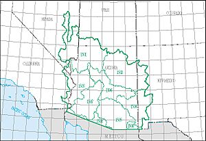
The Lower Colorado water resource region is a large area of land where all the water flows to the same place. Imagine it like a giant funnel! The United States Geological Survey (a science agency) uses these regions to help understand and manage water across the United States. There are 21 such major regions, and each one includes the area drained by a main river or several rivers.
This region is called "Lower Colorado" and has a special code: HUC 15. It's huge, covering about 140,146 square miles (362,970 square kilometers)! To make it easier to study, this big region is divided into 8 smaller areas called subregions. Each subregion has its own 4-digit code, like 1501, 1502, and so on.
The Lower Colorado region includes parts of Arizona, California, Nevada, New Mexico, and Utah. It covers:
- The Colorado River Basin below a spot called Lee Ferry.
- Rivers and streams that start in the U.S. and flow into the Gulf of California.
- Special areas like the Animas Valley and Willcox Playa, which are "closed basins." This means water flows into them but doesn't flow out to the ocean; it usually sinks into the ground or evaporates.
Exploring the Lower Colorado Water Region
The Lower Colorado water resource region is a vital area for water in the southwestern United States. It's important for drinking water, farming, and supporting wildlife. Understanding these regions helps scientists and planners manage water resources for everyone.
Subregions of the Lower Colorado
To better manage and study the vast Lower Colorado region, it is divided into eight smaller areas called subregions. Each subregion has its own unique features and water systems. Below is a list of these subregions, with a brief description of what makes each one special.
| Subregion Code | Subregion Name | What It Covers | States Included | Size (approx.) | Map |
|---|---|---|---|---|---|
| 1501 | Lower Colorado–Lake Mead subregion | This area includes the Colorado River from Lee Ferry down to Hoover Dam. It does not include the Little Colorado River Basin. | Arizona, Nevada, and Utah. | 29,900 sq mi (77,400 km2) | |
| 1502 | Little Colorado subregion | This subregion covers the entire Little Colorado River Basin. | Arizona and New Mexico. | 26,900 sq mi (69,700 km2) | |
| 1503 | Lower Colorado subregion | This part of the Colorado River Basin is below Hoover Dam, but it doesn't include the Gila River Basin. | Arizona, California, and Nevada. | 17,000 sq mi (44,000 km2) | |
| 1504 | Upper Gila subregion | This subregion includes the Gila River Basin above Coolidge Dam, and also the Animas Valley, which is a closed basin. | Arizona and New Mexico. | 15,100 sq mi (39,100 km2) | |
| 1505 | Middle Gila subregion | This area covers the Gila River Basin from Coolidge Dam to where it meets the Salt River Basin. It also includes the Willcox closed basin. | Arizona | 16,900 sq mi (43,800 km2) | |
| 1506 | Salt subregion | This subregion is entirely focused on the Salt River Basin. | Arizona | 13,700 sq mi (35,500 km2) | |
| 1507 | Lower Gila subregion | This area includes the Gila River Basin from where it meets the Salt River Basin all the way to where it joins the Colorado River. | Arizona | 14,800 sq mi (38,300 km2) | |
| 1508 | Sonora subregion | This subregion includes all the water that starts in the U.S. (east of the Colorado River Basin) and eventually flows into the Gulf of California. | Arizona and New Mexico. | 4,830 sq mi (12,500 km2) |
 | Janet Taylor Pickett |
 | Synthia Saint James |
 | Howardena Pindell |
 | Faith Ringgold |


