Lower Franconia Government Region facts for kids
Quick facts for kids
Lower Franconia
Unterfranken
|
|||
|---|---|---|---|
|
|||

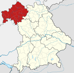
Map of Bavaria highlighting Lower Franconia
|
|||
| Country | Germany | ||
| State | Bavaria | ||
| Region seat | Würzburg | ||
| Area | |||
| • Total | 8,530.99 km2 (3,293.83 sq mi) | ||
| Population
(31 December 2022)
|
|||
| • Total | 1,334,376 | ||
| • Density | 156.41514/km2 (405.1134/sq mi) | ||
| Website | regierung.unterfranken.bayern.de | ||
Lower Franconia (called Unterfranken in German) is one of the seven main government regions in Bavaria, Germany. It is located in the northwestern part of Bavaria.
What is Lower Franconia?
Lower Franconia is a special administrative area. It helps the state government of Bavaria manage things locally. Think of it like a big county or a group of counties working together.
Parts of Lower Franconia
This region is made up of different areas. These include rural districts and urban districts.
Rural Districts
These are areas with smaller towns and countryside.
- Aschaffenburg
- Bad Kissingen
- Haßberge
- Kitzingen
- Main-Spessart
- Miltenberg
- Rhön-Grabfeld
- Schweinfurt
- Würzburg
Urban Districts
These are larger cities that manage themselves.
The main city and administrative center for Lower Franconia is Würzburg.
Black History Month on Kiddle
Famous African-American Inventors:
 | Shirley Ann Jackson |
 | Garett Morgan |
 | J. Ernest Wilkins Jr. |
 | Elijah McCoy |

All content from Kiddle encyclopedia articles (including the article images and facts) can be freely used under Attribution-ShareAlike license, unless stated otherwise. Cite this article:
Lower Franconia Government Region Facts for Kids. Kiddle Encyclopedia.


