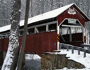
Lower Humbert Covered Bridge facts for kids
Quick facts for kids Lower Humbert Covered Bridge |
|
|---|---|
 |
|
| Coordinates | 39°50′24.5″N 79°19′23″W / 39.840139°N 79.32306°W |
| Carries | Township 312 |
| Crosses | Laurel Hill Creek |
| Locale | Somerset, Pennsylvania, United States |
| Other name(s) | Faidley Covered Bridge |
| Maintained by | Somerset County |
| NBI Number | 557213031230350 |
| Characteristics | |
| Total length | 126.5 ft (38.6 m) |
| Width | 12.3 ft (3.7 m) |
| Height | 8 ft (2.4 m) |
| Load limit | 3 short tons (2.7 t) |
| MPS | Covered Bridges of Somerset County TR |
| NRHP reference No. | 80003638 |
| Added to NRHP | December 10, 1980 |
| Lua error in Module:Location_map at line 420: attempt to index field 'wikibase' (a nil value). | |
The Lower Humbert Covered Bridge, also known as the Faidley Covered Bridge, is a special old bridge in Pennsylvania, United States. It is a type of bridge called a covered bridge, which means it has a roof and sides. This bridge is about 126 feet (38.4 meters) long.
It crosses over Laurel Hill Creek in Somerset County. The bridge was built a long time ago in 1891. Because it is an important historical structure, it was added to the National Register of Historic Places on December 10, 1980. It is one of only ten covered bridges still standing in Somerset County today.
Bridge History
The Lower Humbert Covered Bridge was built in 1891. It uses a special design called a Burr Arch truss, which helps make it strong. This design uses both arches and trusses to support the bridge.
Rebuilding and Repairs
In 1991, the bridge was carefully rebuilt to make sure it stayed safe and strong. During this work, the parts of the bridge that rest on the ground, called abutments, were made even stronger. In January 2006, the bridge had some minor damage to its deck, which is the part cars drive on.
 | Sharif Bey |
 | Hale Woodruff |
 | Richmond Barthé |
 | Purvis Young |

