
Lower North Falls facts for kids
Quick facts for kids Lower North Falls |
|
|---|---|

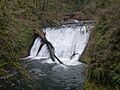
Lower North Falls in the Fall
|
|
| Lua error in Module:Infobox_mapframe at line 185: attempt to index field 'wikibase' (a nil value). | |
| Location | Silver Falls State Park |
| Coordinates | 44°53′29″N 122°38′47″W / 44.89139°N 122.64639°W |
| Type | Plunge |
| Elevation | 1,058 ft (322 m) |
| Total height | 30 ft (9.1 m) |
| Average flow rate |
100 cu ft/s (2.8 m3/s) |
Lower North Falls is a beautiful waterfall found in Silver Falls State Park. This park is located near the city of Salem in Marion County, Oregon, a state in the United States.
The waterfall is in a special spot on the western side of the Mount Hood National Forest. This is where the forest meets the Middle Santiam Wilderness, a wild and natural area. Silver Falls State Park is famous for its many waterfalls. Some of the well-known ones along the Trail of Ten Falls include South Falls, Drake Falls, Middle North Falls, and Winter Falls.
Where to Find Lower North Falls
Lower North Falls is one of several amazing waterfalls along North Silver Creek. It is the last of six waterfalls you'll find as you follow the creek's path. This waterfall is also the furthest one from the main part of the Silver Falls State Park Trail of Ten Falls.
You can reach it by walking along the Canyon Trail. It's about a quarter of a mile north of Drake Falls. Just a short distance upstream, another waterfall called Double Falls is formed by Hullt Creek. Hullt Creek is a smaller stream that flows into the North Fork Silver Creek.
Images for kids
-
Lower North Falls in the Fall
