Ludlow Village Historic District (Ludlow, Massachusetts) facts for kids
Quick facts for kids |
|
|
Ludlow Village Historic District
|
|

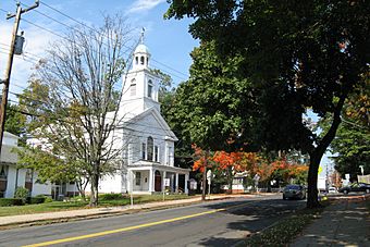
United Church of Christ
|
|
| Location | Roughly bounded by Winsor, Sewall and State Sts. and the Chicopee River, and crossing the Chicopee, above Red Bridge Rd., Ludlow, Massachusetts |
|---|---|
| Area | 190 acres (77 ha) |
| Architect | Multiple |
| Architectural style | Colonial Revival, Queen Anne, Romanesque |
| NRHP reference No. | 93000009 |
| Added to NRHP | February 22, 1993 |
The Ludlow Village Historic District is a special area in Ludlow, Massachusetts. It includes a historic mill village and was once the main business center of the town. This area became important in the late 1800s when jute mills were built along the Chicopee River. Before that, Ludlow Center was the main hub. The district is generally located near Winsor, Sewall, and State Streets, and the Chicopee River. It was added to the National Register of Historic Places in 1993, which means it's a place recognized for its important history.
Exploring Ludlow Village's Past
Ludlow was first settled as part of Springfield way back in 1634. It became its own separate town in 1774. The earliest settlements were along the north side of the Chicopee River, which forms the town's southern border. However, the town's main civic center was originally closer to the middle of Ludlow.
The Wallamamumps Falls on the Chicopee River were a perfect spot for factories that used water power. This type of industry started developing there in the late 1700s. The Falls also had one of the first bridges across the river. This led to more businesses growing around travel and trade. The village economy stayed focused on these mills. A large mill complex was built in 1901, just east of the bridge we see today.
What Makes Up the District?
The Ludlow Village Historic District is made up of three main parts:
- The first part is a group of buildings that were important for the town's government and businesses. This area is found between Winsor, Sewall, East, and Center Streets. Here you can find the Union Church of Christ, built in 1845. There's also the Hubbard Memorial Library, built in 1890. The town's first high school is also here, which is now used as a senior center.
- The second part of the district is the large mill complex itself. This area is located between State Street and the Chicopee River.
- The third part is the old power station that supplied energy to the mill complex. This station is located about 4 miles (6.4 km) upriver, on the Wilbraham side of the river.


