Maarssen facts for kids
Quick facts for kids
Maarssen
|
|||
|---|---|---|---|
|
Town and former municipality
|
|||
 |
|||
|
|||
 |
|||
| Country | Netherlands | ||
| Province | Utrecht | ||
| Municipality | Stichtse Vecht | ||
| Area
(2006)
|
|||
| • Total | 30.86 km2 (11.92 sq mi) | ||
| • Land | 27.20 km2 (10.50 sq mi) | ||
| • Water | 3.66 km2 (1.41 sq mi) | ||
| Population
(1 January 2007)
|
|||
| • Total | 39,363 | ||
| • Density | 1,447/km2 (3,750/sq mi) | ||
| Source: CBS, Statline. | |||
| Time zone | UTC+1 (CET) | ||
| • Summer (DST) | UTC+2 (CEST) | ||
| Website | www.stichtsevecht.nl | ||
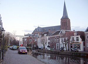
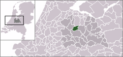
Maarssen is a lovely town in the middle of the Netherlands. It's part of the Utrecht province. This town sits right along the beautiful Vecht river. It's also next to the Amsterdam–Rhine Canal, a busy waterway.
Maarssen is divided into two main parts. The western side is known as Maarssen-Broek. The eastern side is called Maarssen-Dorp. These two areas, along with other small towns nearby, make up the whole Maarssen region. On January 1, 2011, Maarssen joined with the towns of Breukelen and Loenen. Together, they formed a new, larger municipality called Stichtse Vecht.
Exploring Maarssen's Neighborhoods
The area that used to be the municipality of Maarssen included several interesting places. Each of these places has its own unique feel and history.
- Maarssen (often called "Maarssen-dorp") and Maarssen-Broek are the main parts.
- Maarssenbroek is another important area.
- Maarsseveen is a smaller village.
- Molenpolder is known for its polder landscape.
- Oud-Maarsseveen is an older part of Maarsseveen.
- Oud-Zuilen is a historic village nearby.
- Tienhoven is also part of this region.
Getting Around Maarssen
Transportation is important for connecting people and places. Maarssen has good links to other towns and cities.
- The Maarssen railway station helps people travel by train. It connects Maarssen to the wider Dutch railway network.
See also

- In Spanish: Maarssen para niños
 | William M. Jackson |
 | Juan E. Gilbert |
 | Neil deGrasse Tyson |


