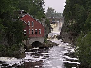
Magaguadavic River facts for kids
The Magaguadavic River is a famous river in New Brunswick, Canada. People say its name, "Magaguadavic," comes from the Maliseet and Passamaquoddy languages. It means "River of Eels."
Contents
About the River
The Magaguadavic River is about 129 kilometers (80 miles) long. This makes it the sixth longest river in New Brunswick. It starts at Lake Magaguadavic in York County. From there, it flows south through a small mountain range called the St. Croix Highlands. Finally, it empties into Passamaquoddy Bay, which is part of the larger Bay of Fundy.
Many smaller streams and rivers flow into the Magaguadavic. These are called tributaries. The river has 103 named tributaries and 55 lakes that feed into it. All the land that drains water into the river covers an area of 1,812 square kilometers (700 square miles).
One special tributary is called "The Canal." It connects Lake Utopia to the Magaguadavic River. Most of the time, water flows from Lake Utopia into the river through The Canal. But sometimes, if the river's water level is very high, the flow can reverse. Then, the Magaguadavic River will actually drain into Lake Utopia for a short time. After that, it flows back through The Canal and out to Passamaquoddy Bay.
Towns and Villages Along the River
The Magaguadavic River flows past several communities from north to south:
In York County
- Thomaston Corner
- Upper Brockway
- Brockway
In Charlotte County
- Flume Ridge
- Pomeroy-Piskahegan
- Lee Settlement
- Second Falls
- Bonny River
- St. George
- Caithness
- Mascarene (This part is where the river meets the sea)
Bridges and Dams
Many bridges and one dam cross the Magaguadavic River. Here are some of them, listed from north to south:
- A railway bridge carries the New Brunswick Southern Railway (NBSR) tracks. It's near the start of the river at Magaguadavic Lake. This bridge is very old, built for an early railway.
- A highway bridge carries Route 3 at Thomaston Corner.
- Another highway bridge carries Tweedside Road at Brockway.
- The "Magaguadavic River No. 7" bridge is a 63-foot (19-meter) covered bridge. It carries Mill Road at Flume Ridge. It was built in 1905.
- The "Pomeroy Bridge" carries Piskahegan Road at Piskahegan.
- A highway bridge carries Red Rock Road at Second Falls.
- A highway bridge carries Route 770 at Canal. People often call this the "Sheldon Lee Bridge." It's named after a local politician who helped build it.
- You can still see the foundations of an old railway bridge. It used to carry the Grand Southern Railway but was taken down in 1988.
- Two highway bridges carry the lanes of the Route 1 highway at St. George.
- The "Upper Bridge" in St. George carries Brunswick Street across the river.
- The St. George Hydroelectric Station has a dam across the river in St. George. This dam helps create electricity. It's just before a deep gorge where the river drops down to sea level.
- The "Lower Bridge" in St. George carries South Street across the river.
The Canal, which connects to Lake Utopia, also has one bridge:
- The "Canal Bridge" is a 127-foot (39-meter) covered bridge. It carries Canal Road across The Canal at Canal. It was built in 1917.
 | Leon Lynch |
 | Milton P. Webster |
 | Ferdinand Smith |


