Magangué facts for kids
Quick facts for kids
Magangué
|
|||
|---|---|---|---|
|
|||
| Nickname(s):
City of the Rivers, Cosmopolitan City
|
|||
| Motto(s):
"Wealth And Prosperity" / "Riqueza y Prosperidad"
|
|||

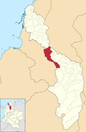
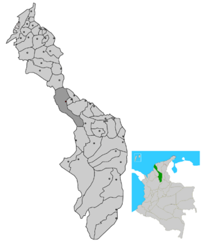
Location of the municipality and town of Magangué in the Bolívar Department of Colombia.
|
|||
| Country | Colombia | ||
| Department | Bolívar Department | ||
| Region | Caribbean | ||
| Founded | April 10, 1610 | ||
| Erection | February 13, 1813 | ||
| Government | |||
| • Type | Mayor and Secretary-General | ||
| Area | |||
| • Total | 1,568 km2 (605 sq mi) | ||
| • Land | 1,043 km2 (403 sq mi) | ||
| • Water | 525 km2 (203 sq mi) 33.48% | ||
| Elevation | 49 m (161 ft) | ||
| Population
(2019 est.)
|
|||
| • Total | 123,982 | ||
| • Density | 79.070/km2 (204.79/sq mi) | ||
| • Demonym | Magangueleño(a) or Magueño(a) | ||
| Time zone | UTC-5 (Colombia Standard Time) | ||
Magangué is an important city in Colombia, located in the Bolívar Department. It sits right on the Magdalena River, which is one of Colombia's biggest rivers. The city is about 20 kilometers north of where the Cauca River joins the Magdalena.
Magangué is a large city with over 198,000 people living there. This makes it one of the biggest cities in Colombia. It's also the second-largest city in the Bolívar Department and a major hub in Colombia's Caribbean Region. Magangué used to have the country's biggest river port. Its location makes it a very important place for trade and travel.
Contents
History of Magangué
Who were the first people in Magangué?
Historians are still learning about the first people who lived in the Magangué area. Early records from Spanish settlers suggest that the original inhabitants were indigenous people. They belonged to the Chimila family, who spoke a language related to the Carib people. These groups lived in the wide river and lake areas of what are now the Bolívar, Sucre, Magdalena, and Cesar departments.
The most powerful leader in the region was the Chimila chief of Mompox. Under him were other local leaders, including those from Maguey, Yati, and Tacaloa.
What were the Maguey people like?
The Maguey people were generally about 1.65 meters tall. They were strong, with black hair, dark skin, and a short, noticeable nose. Unlike some Carib-speaking groups who were fierce warriors, the Maguey people were peaceful. They did not fight the Spanish invaders.
They were skilled farmers, growing crops like cassava and corn. They were also very good at fishing and hunting. Both men and women in the community took part in these important tasks.
Administrative Divisions
How is Magangué organized?
Magangué is divided into different areas for local government. The main city area, called the urban area, has many neighborhoods. There are usually between 50 and 70 neighborhoods.
Some of the well-known neighborhoods include:
- Florida
- Camilo Torres
- Olaya Herrera
- El Sur
- San Pablo
- San José
- El Prado
- San Mateo
- Pastrana
- El Recreo
- Macondo
- Buenos Aires
Outside the main city, there is a rural area. This area is organized into 43 districts.
What are the main rural townships?
The largest townships in the rural area are:
- Ceibal
- Juan Árias
- San Sebastián de Madrid
- La Pascuala
- Yatí
- Cascajal
- Henequén
- El Cuatro
- Betania
- Retiro
- Barbosa
- Coyongal
- San Antonio
Climate in Magangué
What is the weather like in Magangué?
Magangué has a warm and humid climate all year round. The average temperature is around 28 degrees Celsius (82 degrees Fahrenheit). It gets a lot of sunshine, especially from January to March.
There are two main seasons: a dry season and a rainy season. The dry season is usually from December to March. The rainy season starts around April and lasts until November, with the most rain falling from May to October. Even during the dry season, there can be some rain. The air is often very humid.
| Climate data for Magangué (Baracoa Regional Airport), elevation 18 m (59 ft), (1981–2010) | |||||||||||||
|---|---|---|---|---|---|---|---|---|---|---|---|---|---|
| Month | Jan | Feb | Mar | Apr | May | Jun | Jul | Aug | Sep | Oct | Nov | Dec | Year |
| Mean daily maximum °C (°F) | 34.0 (93.2) |
34.7 (94.5) |
35.2 (95.4) |
34.4 (93.9) |
32.9 (91.2) |
32.5 (90.5) |
33.0 (91.4) |
33.0 (91.4) |
32.1 (89.8) |
31.6 (88.9) |
32.0 (89.6) |
33.1 (91.6) |
33.1 (91.6) |
| Daily mean °C (°F) | 28.0 (82.4) |
28.8 (83.8) |
29.1 (84.4) |
29.0 (84.2) |
28.2 (82.8) |
28.1 (82.6) |
28.3 (82.9) |
28.2 (82.8) |
27.6 (81.7) |
27.3 (81.1) |
27.4 (81.3) |
27.7 (81.9) |
28.1 (82.6) |
| Mean daily minimum °C (°F) | 22.2 (72.0) |
22.8 (73.0) |
23.5 (74.3) |
24.2 (75.6) |
24.0 (75.2) |
23.5 (74.3) |
23.7 (74.7) |
23.5 (74.3) |
23.1 (73.6) |
23.2 (73.8) |
23.4 (74.1) |
23.1 (73.6) |
23.3 (73.9) |
| Average precipitation mm (inches) | 10.8 (0.43) |
17.4 (0.69) |
44.4 (1.75) |
88.2 (3.47) |
142.8 (5.62) |
151.2 (5.95) |
175.7 (6.92) |
162.8 (6.41) |
177.8 (7.00) |
152.0 (5.98) |
99.0 (3.90) |
47.3 (1.86) |
1,251.2 (49.26) |
| Average precipitation days (≥ 1.0 mm) | 1 | 2 | 3 | 7 | 10 | 10 | 11 | 12 | 14 | 13 | 8 | 4 | 92 |
| Average relative humidity (%) | 76 | 74 | 74 | 75 | 80 | 81 | 80 | 81 | 83 | 84 | 84 | 80 | 79 |
| Mean monthly sunshine hours | 257.3 | 217.4 | 201.5 | 168.0 | 158.1 | 183.0 | 210.8 | 201.5 | 165.0 | 151.9 | 171.0 | 223.2 | 2,308.7 |
| Mean daily sunshine hours | 8.3 | 7.7 | 6.5 | 5.6 | 5.1 | 6.1 | 6.8 | 6.5 | 5.5 | 4.9 | 5.7 | 7.2 | 6.3 |
| Source: Instituto de Hidrologia Meteorologia y Estudios Ambientales | |||||||||||||
See also
 In Spanish: Magangué para niños
 | William Lucy |
 | Charles Hayes |
 | Cleveland Robinson |


