Maggea, South Australia facts for kids
Quick facts for kids MaggeaSouth Australia |
|||||||||||||||
|---|---|---|---|---|---|---|---|---|---|---|---|---|---|---|---|

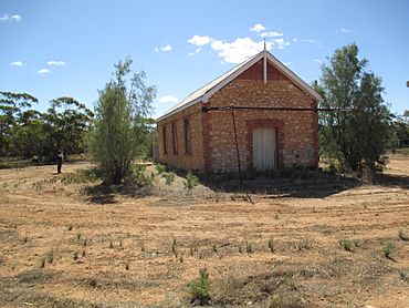
Maggea hall building showing 1919 date of first use
|
|||||||||||||||
| Established | 4 November 1915 (town) 27 March 2003 (locality) |
||||||||||||||
| Postcode(s) | 5311 | ||||||||||||||
| Elevation | 63 m (207 ft)(Railway Station) | ||||||||||||||
| Time zone | ACST (UTC+9:30) | ||||||||||||||
| • Summer (DST) | ACDT (UTC+10:30) | ||||||||||||||
| Location | 45 km (28 mi) E of Swan Reach | ||||||||||||||
| LGA(s) | District Council of Loxton Waikerie | ||||||||||||||
| Region | Murray and Mallee | ||||||||||||||
| County | Albert | ||||||||||||||
| State electorate(s) | Chaffey | ||||||||||||||
| Federal Division(s) | Barker | ||||||||||||||
|
|||||||||||||||
| Footnotes | Adjoining localities | ||||||||||||||
Maggea is a small town and area in the Murray Mallee region of South Australia. It is located on the Stott Highway, a road that connects Swan Reach and Loxton. Maggea used to be on the Waikerie railway line. Today, the town is almost empty because the railway line is no longer used.
What's in a Name?
The name Maggea was chosen in 1915. It comes from an Aboriginal Australian word that means camp.
A Look at the Past
For many years, the town's hall was also used as a school. The school taught children from 1919 until 1967.
Who Lives Here?
In August 2016, a count of the population was done. This count, called the 2016 Australian census, showed that only 12 people lived in Maggea at that time.
How Maggea is Governed
Maggea is part of different government areas.
- For national elections, it is in the federal division of Barker.
- For state elections, it is in the state electoral district of Chaffey.
- For local services, it is part of the District Council of Loxton Waikerie. This council helps manage things like roads and local facilities.
Black History Month on Kiddle
African-American Ballerinas:
 | Precious Adams |
 | Lauren Anderson |
 | Janet Collins |

All content from Kiddle encyclopedia articles (including the article images and facts) can be freely used under Attribution-ShareAlike license, unless stated otherwise. Cite this article:
Maggea, South Australia Facts for Kids. Kiddle Encyclopedia.

