
Magnolia, Florida facts for kids
Quick facts for kids
Magnolia
|
|
|---|---|
|
Former town
|
|

Magnolia
Location in Florida
|
|
| Country | United States |
| State | Florida |
| County | Wakulla County |
| Established | 1820s |
Magnolia, Florida was once a busy port town. It was located in southern Florida, near the city of St. Marks, Florida. This town was started in the 1820s. Today, Magnolia is called an "extinct city" because it no longer exists.
All that is left of Magnolia is its old cemetery. The last known burial there was in 1883. This land is now owned by the St. Joe Paper Company.
Contents
History of Magnolia
How Magnolia Began

In June 1827, Florida had only recently become part of the United States. Four brothers from Maine decided to start a new town. Their names were John, George, Nathaniel, and Weld Hamlin. They chose a spot on the St. Marks River. This was just north of the town of St. Marks. The Ladd family also helped settle the new town of Magnolia.
The Hamlins wanted to create a successful shipping port. They planned to export cotton from here. Cotton would arrive from places north of Magnolia, especially from Tallahassee. The Hamlins had family in Maine who owned a large textile mill.
Growing and Doing Business
Magnolia quickly started to grow. People bought land, and new buildings appeared. Several stores, warehouses, and a hotel were built. The hotel even claimed to be the "best on the gulf."
Goods also came into Magnolia through its port. These items supplied the growing Florida panhandle area. For example, sugar, different types of wine, and other supplies arrived.
At first, a rough dirt road connected Magnolia to Tallahassee. But a railroad was really needed. By 1835, a new rail line was built. This line connected Tallahassee to the town of St. Marks. St. Marks was a bit further south on the river.
This new railroad went around Magnolia. Even though the early trains were pulled by mules, St. Marks gained a big advantage. It became easier to transport goods to and from St. Marks.
By the late 1830s, Magnolia's future looked dim. Most people started to leave. They moved to St. Marks or to a new town called Port Leon. Some even moved their houses and businesses with them. Port Leon was later destroyed by a big hurricane. After that, many people moved back closer to Magnolia and settled in a town called Newport.
In 1829, the U.S. government opened a customs house in Magnolia. This was a place where taxes were collected on goods coming into the country. Magnolia, St. Marks, and Port Leon all benefited from trade. Merchants from Tallahassee and cotton farms in north Florida used these ports. Their products were brought south by wagons and the Tallahassee Railroad.
From the port, steamboats and sailing ships carried these goods away. As Magnolia became less important, the customs house moved. It was transferred to St. Marks in the 1830s.
Old maps of Magnolia show its layout. There were six streets running one way and five streets running another. The town had 34 blocks with lots, homes, or businesses.
On September 13, 1843, a powerful hurricane hit the area. It brought a 10-foot storm surge. This storm badly damaged what was left of Magnolia. It also destroyed Port Leon and harmed St. Marks.
It's interesting to know that another town named Magnolia existed later. This second Magnolia was in Clay County, Florida. It was located on the St. Johns River around the time of the American Civil War.
Photo gallery
-
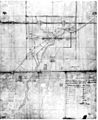
Old map shows location of Magnolia
-
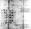
Old map with close view of Magnolia's streets
-
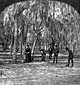
People enjoying croquet in an oak grove in Magnolia
-
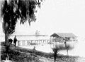
The steamer pier at Magnolia
-
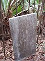
Cemetery headstone worn by age


Magnolia was important enough that its local bank could print its own money. This happened between 1832 and 1838.
Other reading
- The Ladd Family History
