Maillezais facts for kids
Quick facts for kids
Maillezais
|
||
|---|---|---|

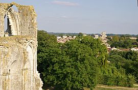
Maillezais seen from the Abbey of Saint-Pierre
|
||
|
||
| Country | France | |
| Region | Pays de la Loire | |
| Department | Vendée | |
| Arrondissement | Fontenay-le-Comte | |
| Canton | Fontenay-le-Comte | |
| Intercommunality | Vendée Sèvre Autise | |
| Area
1
|
20.33 km2 (7.85 sq mi) | |
| Population
(Jan. 2019)
|
921 | |
| • Density | 45.30/km2 (117.33/sq mi) | |
| Time zone | UTC+01:00 (CET) | |
| • Summer (DST) | UTC+02:00 (CEST) | |
| INSEE/Postal code |
85133 /85420
|
|
| Elevation | 1–18 m (3.3–59.1 ft) (avg. 7 m or 23 ft) |
|
| 1 French Land Register data, which excludes lakes, ponds, glaciers > 1 km2 (0.386 sq mi or 247 acres) and river estuaries. | ||
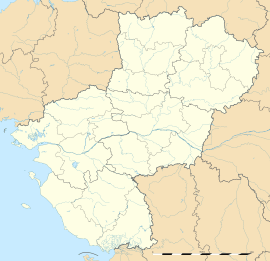
Maillezais is a small town, also known as a commune, located in the western part of France. It is found in the Vendée department, which is part of the Pays de la Loire region. This area is known for its interesting history and natural beauty.
About Maillezais
A commune is like a local government area, similar to a town or a small city. Maillezais is home to about 921 people, based on numbers from January 2019. The town is led by a mayor, who helps manage local services and represents the community. The current mayor is Jean Tallineau.
Geography of Maillezais
Maillezais is situated in a relatively low-lying area. Its elevation, or height above sea level, ranges from just 1 meter (about 3 feet) to 18 meters (about 59 feet). The average elevation is around 7 meters (about 23 feet). The total area of the commune is 20.33 square kilometers (about 7.85 square miles). Its location in the Vendée department means it is part of a region with diverse landscapes, from coastal areas to marshlands.
See also
 In Spanish: Maillezais para niños
 | Misty Copeland |
 | Raven Wilkinson |
 | Debra Austin |
 | Aesha Ash |


