Malabon, Oregon facts for kids
Quick facts for kids
Malabon, Oregon
|
|
|---|---|

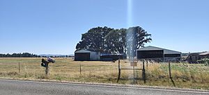
A farm in Malabon, Oregon
|
|
| Country | United States |
| State | Oregon |
| County | Lane |
| Elevation | 377 ft (115 m) |
| Time zone | UTC-8 (Pacific (PST)) |
| • Summer (DST) | UTC-7 (PDT) |
| GNIS feature ID | 1166549 |
Malabon (also known as Clear Lake) is a small, historic community in Lane County, Oregon, USA. It is not a city with its own government. Today, you will find many rural houses and farms here. Malabon is located northwest of Eugene, very close to Mahlon Sweet Field, which is an airport.
Contents
Exploring Malabon's Location
Malabon is found in the beautiful state of Oregon. It is part of Lane County. This area is known for its peaceful countryside.
Waterways Near Malabon
A body of water called Clear Lake flows right through the Malabon area. This "lake" is actually a wider part of a stream. That stream is called Amazon Creek. Amazon Creek eventually flows into the Long Tom River.
Malabon's Elevation
Malabon sits at an elevation of 377 feet (about 115 meters) above sea level. This means it is not very high up in the mountains.
A Glimpse into Malabon's Past
Malabon has a history, even though it's a quiet place today. It was once a recognized community.
Malabon and the Railroad
The Oregon Historical Society has old records that mention Malabon. These records include timetables from the Southern Pacific Railroad. This shows that Malabon was once a stop or a point of interest for trains. This was important for travel and trade long ago.
Education in the Area
Even though Malabon is a small community, there is a school nearby.
Malabon Elementary School
Malabon Elementary School is located about 3.5 miles (5.6 kilometers) east-southeast of the historic community. This school serves the children living in the surrounding rural areas.
 | James Van Der Zee |
 | Alma Thomas |
 | Ellis Wilson |
 | Margaret Taylor-Burroughs |


