Manaure, Cesar facts for kids
Quick facts for kids
Manaure
|
|||
|---|---|---|---|
|
Town
|
|||
|
|||

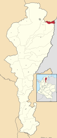
Location of the municipality and town of Manaure in the Department of Cesar.
|
|||
| Country | Colombia | ||
| Region | Caribbean | ||
| Department | Cesar | ||
| Foundation | 1874 | ||
| Area | |||
| • Total | 1,264 km2 (488 sq mi) | ||
| Population
(Census 2018)
|
|||
| • Total | 9,313 | ||
| • Density | 7.368/km2 (19.083/sq mi) | ||
| Time zone | UTC-5 | ||
| Website | manaurebalcondelcesar-cesar.gov.co |
||
Manaure, also called Balcón del Cesar (which means "Cesar's Balcony"), is a town and municipality in Colombia. It's located in the northeastern part of the Cesar Department, right on the Serranía del Perijá mountain range.
Contents
Geography of Manaure
Manaure is located in a beautiful area with mountains. To the north, it shares a border with La Jagua del Pilar in the Department of La Guajira. To the east, it borders Venezuela, and to the south, it's next to Los Robles La Paz.
Most of Manaure is mountainous, with some areas reaching high altitudes. The eastern side has peaks between 1,000 and 2,500 meters (about 3,280 to 8,200 feet) above sea level. The land gets lower as you go west. Two important rivers flow through the municipality: the Manaure River and the Chiriaimo River.
History of Manaure
Early History: Before Europeans Arrived
Long before Europeans came to the Americas, the Manaure region was home to the Bohures people. They were descendants of the Caribs, who traveled to this area from what is now Venezuela, crossing the Serranía del Perijá mountains.
Modern History: Becoming a Town
The area where Manaure is now was once part of Los Robles La Paz. A farmer named Buenaventura Maya founded the village of Manaure on January 1, 1874. He named it after Cacique Manaure, a leader who ruled in the Maracaibo region.
Manaure became important in the late 1800s because of its coffee and cocoa farms. In 1913, it became a corregimiento (a smaller administrative division) of Los Robles La Paz.
During a time of civil unrest in Colombia in the late 1950s, many people moved to Manaure. These new residents came from different parts of Colombia, especially from the Department of North Santander. They bought farms and helped grow the coffee plantations even more.
These new residents also wanted Manaure to become its own municipality, separate from Los Robles La Paz. Local leaders like Guillermo Araque and Arturo Navarro worked hard for this. They gathered many signatures to support their request. Their petition also followed a special "Law of Frontiers" that helped villages near national borders. The Governor of Cesar at the time, José Guillermo Castro Castro, fully supported their efforts.
Finally, Manaure was officially made a municipality of the Cesar Department. This happened through Ordinance 28 on November 28, 1980, passed by the Department Assembly of Cesar. The law was signed on December 21 of the same year.
The first mayor of Manaure was Alfonso Murgas, who was appointed. Later, mayors like Guillermo Araque García and Enrique Campo Mieles served. Enrique Campo Mieles was the first mayor chosen by popular vote. Virgilio Ardila was also elected mayor and was even recognized as one of the best mayors in Colombia.
Climate of Manaure
| Climate data for Manaure/Los Robles La Paz (San Jose D Oriente), elevation 850 m (2,790 ft), (1971–2000) | |||||||||||||
|---|---|---|---|---|---|---|---|---|---|---|---|---|---|
| Month | Jan | Feb | Mar | Apr | May | Jun | Jul | Aug | Sep | Oct | Nov | Dec | Year |
| Mean daily maximum °C (°F) | 29.9 (85.8) |
30.5 (86.9) |
30.6 (87.1) |
30.1 (86.2) |
29.3 (84.7) |
29.5 (85.1) |
30.4 (86.7) |
30.3 (86.5) |
29.4 (84.9) |
28.7 (83.7) |
28.7 (83.7) |
28.8 (83.8) |
29.7 (85.5) |
| Daily mean °C (°F) | 24.3 (75.7) |
24.8 (76.6) |
25.3 (77.5) |
25.2 (77.4) |
24.8 (76.6) |
25.2 (77.4) |
25.5 (77.9) |
25.4 (77.7) |
25.0 (77.0) |
24.4 (75.9) |
24.5 (76.1) |
24.3 (75.7) |
24.9 (76.8) |
| Mean daily minimum °C (°F) | 17.9 (64.2) |
17.8 (64.0) |
18.6 (65.5) |
18.7 (65.7) |
18.8 (65.8) |
20.0 (68.0) |
18.8 (65.8) |
19.2 (66.6) |
19.3 (66.7) |
18.9 (66.0) |
18.8 (65.8) |
17.4 (63.3) |
18.7 (65.7) |
| Average precipitation mm (inches) | 21.1 (0.83) |
19.8 (0.78) |
41.5 (1.63) |
166.2 (6.54) |
181.8 (7.16) |
113.4 (4.46) |
55.2 (2.17) |
82.1 (3.23) |
150.1 (5.91) |
235.9 (9.29) |
143.4 (5.65) |
33.7 (1.33) |
1,244.2 (48.98) |
| Average precipitation days | 2 | 3 | 5 | 11 | 16 | 12 | 9 | 13 | 15 | 17 | 12 | 4 | 119 |
| Average relative humidity (%) | 79 | 79 | 77 | 78 | 80 | 80 | 78 | 79 | 80 | 81 | 80 | 79 | 79 |
| Mean monthly sunshine hours | 229.4 | 197.9 | 204.6 | 165.0 | 155.0 | 162.0 | 176.7 | 164.3 | 138.0 | 151.9 | 156.0 | 198.4 | 2,099.2 |
| Mean daily sunshine hours | 7.4 | 7.0 | 6.6 | 5.5 | 5.0 | 5.4 | 5.7 | 5.3 | 4.6 | 4.9 | 5.2 | 6.4 | 5.8 |
| Source: Instituto de Hidrologia Meteorologia y Estudios Ambientales | |||||||||||||
See also
 In Spanish: Manaure Balcón del Cesar para niños
 | Georgia Louise Harris Brown |
 | Julian Abele |
 | Norma Merrick Sklarek |
 | William Sidney Pittman |


