
Mangere Bridge (bridges) facts for kids


The Māngere Bridge, also known as the Manukau Harbour Crossing, is a big bridge in Auckland, New Zealand. It crosses the Manukau Harbour, connecting the suburb of Māngere Bridge on the south side with Onehunga on the north side. It's a dual motorway bridge, meaning it has two separate parts for traffic.
The older part of the bridge was finished in 1983. It has four lanes for cars and trucks. There's also a special path for bikes and people walking underneath it. By the year 2000, about 80,000 vehicles used this bridge every day. This caused a lot of traffic jams.
To fix the traffic problem, a new part of the bridge was built next to the 1983 bridge. It opened in 2010. This new section doubled the number of lanes for general traffic to eight. It also added two special lanes for buses. So, now there are 10 lanes in total across the harbour. Building the new bridge took a while because of disagreements about its design and how it would be paid for.
Past Bridges
First Bridge (1875)
The very first bridge here was made of wood. It was designed by Reverend Dr. Arthur Guyon Purchas and opened in January 1875. This bridge was quite narrow. It also started to get damaged by tiny sea worms called shipworms. By 1910, many parts of the bridge had to be replaced. It was so narrow that even people walking could barely pass a car safely. The bridge was eventually considered unsafe and closed in 1914, then taken down.
Old Māngere Bridge (1914)
A new bridge, made of concrete, opened in January 1914 (some say 1915). It was about 246 meters long. This bridge was designed by R.F. Moore, who also designed the famous Grafton Bridge. It was a big engineering success for its time. It was 11.6 meters wide, wide enough for two tram tracks. However, it wasn't tall enough for anything but small boats to pass underneath.
This concrete bridge soon became too small for all the traffic. Its foundations also started to sink. The bridge was closed to cars in 1983. It has slowly been falling apart, especially after ships accidentally hit it. One ship, the Spirit of Resolution, crashed into it in 2005 during strong winds.
Because of problems with the concrete and steel, people first thought the old bridge would be taken down and replaced with a new footbridge. But many people complained about this. So, plans for its removal were not decided until 2012. A new bridge for walking, cycling, and fishing was planned to replace it.
New Replacement Bridge
The New Zealand Transport Agency is building a brand new bridge to replace the Old Māngere Bridge. This new bridge will use the same starting points as the old one. However, it will be built further from the port. This will allow small boats to pass underneath it easily. The new bridge will be at least eight meters wide. In some areas, it will be up to 12 meters wide, perfect for fishing. This replacement bridge is expected to be finished by 2023.
Motorway Bridge (1983)
The older part of the current Māngere Bridge opened in 1983. Today, about 80,000 vehicles use it every day. This motorway bridge took 8 years to build. There were some delays, including a long break due to worker strikes.
To handle more cars, a second part of the 1983 bridge was built next to it. This new section was finished in 2010 and cost a lot of money. It is 650 meters long. It has four lanes for southbound traffic (going south). The 1983 bridge now carries only northbound traffic (going north). The new section also has two special lanes for buses. One lane is just for local traffic between Onehunga and the Māngere Bridge suburb. In total, there are now 10 lanes across the harbour.
Bridge Duplication Project

Project History
Funding the New Bridge
In 2006, the government announced that money would be given to help speed up important transport projects. This included funds to build a second bridge next to the 1983 Māngere Bridge. At first, only a small amount of money was approved to study the project. The bridge was expected to cost many millions of dollars.
Wider Road Improvements
As part of this big project, the motorway was also made wider. It grew from four lanes to six lanes in some areas. The road connection at Onehunga was also planned to be greatly improved. This was to make it easier to get onto the motorway and reduce traffic jams. Officials considered charging a toll to use the new lanes to help pay for the bridge. However, they decided not to charge tolls before starting construction.
Public Transport Link
In 2007, there was talk about making the new bridge ready for a future train line. This train line would connect Auckland City to Auckland Airport. The existing railway line ends near the north side of the bridge. Local councils pushed for the bridge to be designed so a train line could be added easily.
In September 2007, a transport authority offered to pay millions of dollars to make sure the bridge could support a future train link. The idea was for the train line to run on the new bridge's supports, underneath the motorway. This would save a lot of money compared to building a separate train bridge.
Interchange Issues
In 2007, the Auckland City Council approved widening the motorway near the bridge. However, they did not like the new road connection design proposed for the north side of the bridge. Residents were worried that the new connection would separate their suburb from the harbour. Because of these concerns, the transport agency decided to build the new bridge without including the new road connection for a while.
Bridge Design
The transport agency made sure the new bridge could support a future train line. Three of the eight main supports were built extra strong for this purpose.
The bridge has 7 main supports with 14 columns in total. It used a huge amount of reinforced concrete and steel. Some of the piles were driven 50 meters deep into the ground. This was done to avoid problems with the soft ground in the Manukau Harbour.
The project also included widening about 4 kilometers of the motorway. This was to make sure the new bridge's extra lanes could be used well. Paths for walkers and cyclists were also improved. A new walking and cycling bridge was built over Onehunga Harbour Road. This connects Onehunga to the Māngere Bridge suburb and to the Waikaraka Cycleway.
Construction and Opening
Building the new bridge officially started on April 9, 2008. It was built by a group of companies working together. The bridge was finished on July 25, 2010, which was seven months earlier than planned. After the new bridge opened, the old 1983 bridge was temporarily closed for repairs. With both bridges open, there are now 10 traffic lanes across the harbour, including 2 bus lanes.
Related Improvements
Many other improvements were made as part of the bridge project. These included a new 3.5-meter wide path for walking and cycling over Beachcroft Road. Another new path was built over Onehunga Harbour Road near the Old Māngere Bridge. An underpass beneath the motorway was also upgraded. Links to the walking and cycling paths along the harbour were also improved. The construction area along the southern harbour front was turned into a nice park with Pohutukawa trees.
Images for kids
-
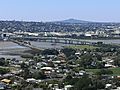
View of the motorway section of the Māngere Bridge and the Old Māngere Bridge, during its replacement (November 2020)
-
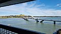
View of the new Māngere Bridge seen from the motorway bridge
-
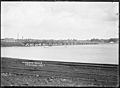
Original wooden bridge circa 1900
-
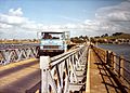
The Old Māngere Bridge, supported by a temporary bailey bridge, circa 1980
-
View of the replacement bridge during construction in 2022


.jpg)
.jpg)

