Manouane River (Péribonka River tributary) facts for kids
Quick facts for kids Manouane River |
|
|---|---|
 |
|
| Country | Canada |
| Province | Quebec |
| Region | Saguenay–Lac-Saint-Jean |
| Regional County Municipality | Le Fjord-du-Saguenay Regional County Municipality |
| Unorganized Territory | Mont-Valin, Quebec |
| Physical characteristics | |
| Main source | Manouane Lake Saguenay–Lac-Saint-Jean 510 m (1,670 ft) 51°41′53″N 70°44′41″W / 51.69806°N 70.74472°W |
| River mouth | Peribonka River Mont-Valin, Quebec Unorganized territory 180 m (590 ft) 49°30′21″N 71°10′32″W / 49.50583°N 71.17556°W |
| Length | 209 km (130 mi) |
| Basin features | |
| Tributaries |
|
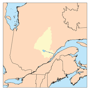
The Manouane River is a river in Quebec, Canada. It flows through the Mont-Valin, Quebec area. This river is a branch of the larger Peribonka River.
The main activity in this river valley is forestry, which means harvesting trees. After that, recreational tourism is important. This includes activities like fishing or camping. Hydroelectricity, which is making electricity from water power, is also a key activity.
Forest roads R0258 and R0251 help people get around the Manouane River Valley. These roads also serve the Georges River and the Manouaniche River areas.
The surface of the Péribonka River usually freezes over from late November to early April. However, it's generally safe to travel on the ice from mid-December to late March.
Contents
Exploring the Manouane River's Path
The Manouane River starts at Manouane Lake. This lake is very large, about 54 kilometres (34 mi) long and 33 kilometres (21 mi) wide. It sits at an elevation of 510 metres (1,670 ft) above sea level.
From a dam at the start of Manouane Lake, the Manouane River flows for about 209.0 kilometres (129.9 mi). It travels entirely through forest areas.
Upper Manouane River Journey
The upper part of the Manouane River is about 145.3 kilometres (90.3 mi) long. Here's how it flows:
- It goes east, then north, passing through Lake Opitoune.
- It turns south, crossing Lake Opitounis.
- It continues south, then northeast, through Otapoco Lake.
- It flows southwest through Lake Shortcut.
- The river then travels southwest and south, picking up water from other lakes like Panache and Radio. It also curves east before meeting the "Rivière aux Outardes".
- It flows south to the outlet of Lake Grand Détour.
- It continues southwest, where it meets the water from Portage Lake and Suzanne Lake.
- Finally, it flows northwest, crossing forest road R0251. Along this path, it collects water from the Naja River, Lake Grand Nénuphar, and creek Milot, before joining the Petite rivière Manouane.
Lower Manouane River Journey
The lower part of the Manouane River is about 63.7 kilometres (39.6 mi) long. This is how it continues:
- It flows south, passing through Lac Duhamel. It then meets the Castor-Qui-Cale River.
- It continues south to where the Houlière River joins it.
- Next, it flows south to the George River.
- It keeps going south to the Alma River.
- It then flows south to the Manouaniche River.
- Finally, it travels southwest until it reaches its mouth, where it empties into the Peribonka River.
Where the Manouane River Ends
The Manouane River joins the east bank of the Peribonka River. This meeting point is:
- About 18.6 kilometres (11.6 mi) west of the Pipmuacan Reservoir.
- About 20.1 kilometres (12.5 mi) northwest of the dam at Lake Pamouscachiou.
- About 55.8 kilometres (34.7 mi) southeast of the dam at Lake Péribonka, which the Peribonka River flows through.
- About 108.3 kilometres (67.3 mi) north of where the Peribonka River meets lac Saint-Jean.
- About 108.9 kilometres (67.7 mi) north of the mouth of lac Saint-Jean.
From the Manouane River's mouth, the water flows south for 143.3 kilometres (89.0 mi) down the Peribonka River. It then crosses lac Saint-Jean to the east for 29.3 kilometres (18.2 mi). After that, it follows the Saguenay River east for 155 kilometres (96 mi) until it reaches Tadoussac, where it joins the mighty Saint Lawrence River.
The Name of the Manouane River
The name "Manouan" was first seen on a map from 1705. This name was officially recognized in 1945. It has been spelled in different ways over time, like Manuan, Manowan, and Manouan.
The name comes from the Montagnais language. "Manauan Shakaikan" means "lake where we collect eggs." This name comes from the words manneu (meaning "he removes it by hand"), uau (egg), and shakaikan (lake). It is believed that the Montagnais people used to collect bird eggs from the islands and shores of this lake.
The official name "Rivière Manouane" was recorded on December 5, 1968, by the Commission de toponymie du Québec, which is like a naming committee for places in Quebec.
 | Selma Burke |
 | Pauline Powell Burns |
 | Frederick J. Brown |
 | Robert Blackburn |

