Pipmuacan Reservoir facts for kids
Quick facts for kids Pipmuacan Reservoir |
|
|---|---|

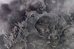
Partial view of Pipmuacan Reservoir from the International Space Station
|
|
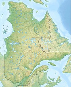
| Location | Mont-Valin, Le Fjord-du-Saguenay Regional County Municipality / Lac-au-Brochet, La Haute-Côte-Nord Regional County Municipality, Quebec |
| Coordinates | 49°39′42″N 70°16′18″W / 49.66167°N 70.27167°W |
| Type | artificial |
| Primary inflows | Betsiamites River |
| Primary outflows | Betsiamites River and Shipshaw River |
| Basin countries | Canada |
| Max. length | 150 km (93 mi) |
| Max. width | 19 km (12 mi) |
| Surface area | 978 km2 (378 sq mi) |
| Water volume | 13.9 km3 (3.3 cu mi) |
| Surface elevation | 396 m (1,300 ft) |
The Pipmuacan Reservoir (in French, Réservoir Pipmuacan) is a large lake created by people. It sits on the border of two regions in Quebec, Canada: Saguenay–Lac-Saint-Jean and Côte-Nord. You can find it about 130 kilometers north of a city called Chicoutimi. This special lake helps control the water flow for power plants that make electricity. It's an important part of the Betsiamites River system.
This reservoir has a total surface area of 978 square kilometers. It's shaped very unevenly, with many deep bays and islands, especially in its western part. A large, rounded piece of land sticks out into the middle of the lake. The main rivers that flow into it are the Betsiamites, Sylvestre, Hirondelles, and Pipmuacan Rivers.
What's in a Name?
The reservoir is named after a natural lake called Lake Pipmuacan, which was covered by water when the reservoir was made. The name comes from the Innu language. It might mean "arrow."
In 1960, the Geographic Board shared a story. Missionaries from the Côte-Nord region said the Innu people gave the lake this name. It was to remember their last fight with the Iroquois people on Mount Pigmaugan (Pipmuacan), which overlooks the water. You might see the name spelled in other ways too, like Pipmuakan or Pipmakan.
Fishing Fun!
If you like fishing, the Pipmuacan Reservoir is a great spot! You can find several types of sport fish here. These include northern pike, lake trout, brook trout, and lake whitefish.
There are even special businesses called outfitters near the reservoir. They offer fishing trips and places to stay for visitors.
How the Reservoir Was Built
The Pipmuacan Reservoir was created in October 1953. This happened when Hydro-Québec, a big electricity company, started building dams and a power plant. This project was called Bersimis-1.
The first dam was very long, about 674 meters, and 74 meters high. It was built between two mountains around a lake called Lake Cassé. The second dam was 315 meters long. It stopped water from flowing into the Desroches River. The reservoir's spillway, which lets extra water out, was cut through a mountain between the two dams. All the building work was finished by 1956.
In 2002, Hydro-Québec changed the path of part of the Portneuf River. They sent its water north into the Pipmuacan Reservoir. This was done to make the Bersimis power stations even more powerful. They are also looking into changing the path of part of the Sault aux Cochons River. This would help them make the existing power stations work even better.
 | Selma Burke |
 | Pauline Powell Burns |
 | Frederick J. Brown |
 | Robert Blackburn |


