Manteyer facts for kids
Quick facts for kids
Manteyer
|
||
|---|---|---|

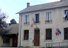
The town hall in Manteyer
|
||
|
||
| Country | France | |
| Region | Provence-Alpes-Côte d'Azur | |
| Department | Hautes-Alpes | |
| Arrondissement | Gap | |
| Canton | Veynes | |
| Intercommunality | Buëch Dévoluy | |
| Area
1
|
25.63 km2 (9.90 sq mi) | |
| Population
(Jan. 2019)
|
427 | |
| • Density | 16.660/km2 (43.15/sq mi) | |
| Time zone | UTC+01:00 (CET) | |
| • Summer (DST) | UTC+02:00 (CEST) | |
| INSEE/Postal code |
05075 /05400
|
|
| Elevation | 890–1,974 m (2,920–6,476 ft) (avg. 1,040 m or 3,410 ft) |
|
| 1 French Land Register data, which excludes lakes, ponds, glaciers > 1 km2 (0.386 sq mi or 247 acres) and river estuaries. | ||
Manteyer is a small village located in the Hautes-Alpes department in France. It is a quiet place where people live and work.
How Many People Live Here?
The number of people living in Manteyer has changed over the years. This is called the population. Knowing the population helps us understand how a village grows or shrinks.
| Historical population | ||
|---|---|---|
| Year | Pop. | ±% |
| 1962 | 193 | — |
| 1968 | 200 | +3.6% |
| 1975 | 178 | −11.0% |
| 1982 | 211 | +18.5% |
| 1990 | 222 | +5.2% |
| 1999 | 305 | +37.4% |
| 2008 | 414 | +35.7% |
As you can see from the numbers, Manteyer's population has generally increased over time. This means more people have chosen to live in this lovely area.
Getting Around Manteyer
Roads are very important for connecting villages and towns. They allow people to travel, transport goods, and visit friends and family.
Roads and Transport
Several roads pass through Manteyer. These include the D18, D118, and D118L roads. These roads help residents and visitors move easily in and out of the village.
See also
 In Spanish: Manteyer para niños
 | Selma Burke |
 | Pauline Powell Burns |
 | Frederick J. Brown |
 | Robert Blackburn |


