Manzanares, Ciudad Real facts for kids
Quick facts for kids
Manzanares
|
||
|---|---|---|

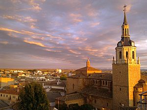
Sunset in Manzanares
|
||
|
||
| Country | Spain | |
| Autonomous community | Castilla–La Mancha | |
| Province | Ciudad Real | |
| Area | ||
| • Total | 474 km2 (183 sq mi) | |
| Elevation | 654 m (2,146 ft) | |
| Population
(2018)
|
||
| • Total | 18,043 | |
| • Density | 38.07/km2 (98.59/sq mi) | |
| Demonym(s) | Manzanareño, Manzanareña | |
| Time zone | UTC+1 (CET) | |
| • Summer (DST) | UTC+2 (CEST) | |
| Postal code |
13200
|
|
Manzanares is a town, also known as a municipality, located in Spain. It is found in the central region of Castilla–La Mancha, within the Ciudad Real province. As of 2014, about 18,924 people lived in Manzanares. The town is conveniently located near a major highway called the Autovía A-4, which is also known as the Autovía del Sur.
Exploring Manzanares
Manzanares is a place with its own unique history and important buildings. It's a great example of a Spanish town with a strong community.
Important Buildings
The main church in Manzanares is called the Iglesia de la Asunción. It is dedicated to the Assumption of Mary, which is an important event in Christian belief. This church is a central part of the town's history and culture.
Nearby Communities
A village called Llanos del Caudillo used to be part of Manzanares. It was created in the 1950s by a group called the Instituto Nacional de Colonización. This group helped set up new farming communities. In the 1990s, Llanos del Caudillo became its own separate municipality.
See also
 In Spanish: Manzanares (Ciudad Real) para niños
 | Percy Lavon Julian |
 | Katherine Johnson |
 | George Washington Carver |
 | Annie Easley |


