
Marcilly-le-Hayer facts for kids
Quick facts for kids
Marcilly-le-Hayer
|
||
|---|---|---|
 |
||
|
||

Marcilly-le-Hayer
Location in France

Marcilly-le-Hayer
Location in Grand Est
|
||
| Country | France | |
| Region | Grand Est | |
| Department | Aube | |
| Arrondissement | Nogent-sur-Seine | |
| Canton | Saint-Lyé | |
| Intercommunality | Orvin et Ardusson | |
| Area
1
|
34.34 km2 (13.26 sq mi) | |
| Population
(Jan. 2019)
|
727 | |
| • Density | 21.171/km2 (54.83/sq mi) | |
| Time zone | UTC+01:00 (CET) | |
| • Summer (DST) | UTC+02:00 (CEST) | |
| INSEE/Postal code |
10223 /10290
|
|
| 1 French Land Register data, which excludes lakes, ponds, glaciers > 1 km2 (0.386 sq mi or 247 acres) and river estuaries. | ||

Marcilly-le-Hayer is a small town, also known as a commune, located in the Aube area of north-central France. A "commune" is like a local government area, similar to a township or a small city. The "Aube" is one of France's 101 "départements", which are administrative regions.
Contents
Discovering Marcilly-le-Hayer
Marcilly-le-Hayer is a charming place with a rich history. It is known for its peaceful countryside and traditional French feel. The area is mostly rural, meaning it has lots of farms and natural spaces.
Where is Marcilly-le-Hayer?
This commune is found in the Grand Est region of France. It is part of the Aube department. The nearest larger town is Nogent-sur-Seine. Marcilly-le-Hayer is situated about 123 meters (around 400 feet) above sea level.
Life in Marcilly-le-Hayer
As of January 2019, about 727 people live in Marcilly-le-Hayer. This makes it a small community where many people likely know each other. The total area of the commune is about 34.34 square kilometers (around 13.26 square miles). This means there's plenty of space for everyone.
Local Government
Like all communes in France, Marcilly-le-Hayer has its own local government. The head of the local government is called the mayor. From 2008 to 2014, the mayor of Marcilly-le-Hayer was Germain Douine. The local government works to manage public services and local affairs for the people living in the commune.
Images for kids
-
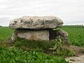
The Dolmen du Vamprin, an ancient stone monument near Marcilly-le-Hayer.
-
The official coat of arms for Marcilly-le-Hayer.
See also
 In Spanish: Marcilly-le-Hayer para niños
