Marcus Passage facts for kids
Quick facts for kids Marcus Passage |
|
|---|---|
| Kennedy Gap | |

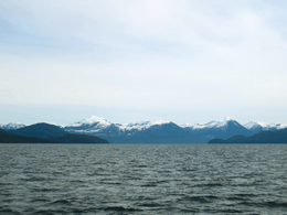
Looking Southeast across Marcus Passage, Smith Island is to the left, and Kennedy Island is to the right
|
|
| Location | British Columbia, Canada |
| Coordinates | 54°06′22″N 130°15′24″W / 54.10611°N 130.25667°W |
Marcus Passage is a waterway located on the North Coast of British Columbia, Canada. It is found offshore from the mouth of the Skeena River, south and west of Smith Island. This passage connects Chatham Sound with Telegraph Passage. On its southern side, Marcus Passage is bordered by a large area of sand that becomes dry at low tide. This area is called Base Sand, and some people know it as Wilson Bar.
Water Movement in Marcus Passage
The water in Marcus Passage moves a lot with the tides. When the tide comes in (this is called a tidal flood), the water can flow quite fast. It can reach speeds of about 3.5 knots (which is roughly 6.5 kilometers per hour).
When the tide goes out (this is called a tidal ebb), the water can move even faster. It can stream at up to 5 knots (about 9.3 kilometers per hour).
Shallow Areas and Sand Waves
Marcus Passage has two main shallow areas, known as shoals, which can make it tricky for boats. One shoal stretches from De Horsey Passage to Base Sand. The other goes from De Horsey Island to Kennedy Island.
In these shallow areas, there are also sand waves. These are like underwater sand dunes. Some of these sand waves can be as tall as 1.6 meters (about 5 feet).
 | Audre Lorde |
 | John Berry Meachum |
 | Ferdinand Lee Barnett |


