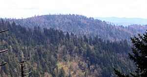
Marks Knob facts for kids
Marks Knob is a cool mountain located in the Great Smoky Mountains in the southeastern United States. It stands tall at about 6,169 feet (1,880 meters) high. The very top of the mountain is covered in a thick forest of spruce and fir trees. Reaching the summit of Marks Knob is a challenge for hikers. It's one of the hardest peaks to get to among the "Southern Sixers," which are the tallest mountains in the southern Appalachians.
Contents
About Marks Knob
Marks Knob is the taller of two peaks on a ridge called Dashoga Ridge. The other peak is Mount Hardison. Dashoga Ridge goes from Mount Yonaguska down to the Raven Fork Valley. This ridge runs almost next to the main Great Smoky Mountains range.
Marks Knob has two peaks, but the one furthest south is the true summit. The entire mountain is located in Swain County, North Carolina. Water from Dashoga Ridge flows into Raven Fork, which then joins the Oconaluftee River. The rocks that make up Dashoga Ridge are very old. They are mostly metamorphic sandstones from a time called the Precambrian era.
A Mountain's History
Marks Knob was not always a well-known mountain. Unlike many other tall peaks in the Eastern Smokies, no state or county lines cross its summit. Because of this, it didn't get much attention for a long time.
In the early 1930s, some trail guides called the mountain "Cam's Knob." They also said it was taller than 6,140 feet. In the 1920s and early 1930s, there were two trails that helped people get to Dashoga Ridge. These trails connected to logging camps at Smokemont and Straight Fork.
Old Trails to the Summit
One of the old trails was called the Rosser Trail. It started near Smokemont and went across Hughes Ridge to Enloe Creek. Then it crossed Highland Ridge to the Raven Fork Valley. The trail continued north along Raven Fork to an area called Three Forks. This is where three parts of Raven Fork come together.
Beyond Three Forks, the Rosser Trail went north up Dashoga Ridge. It crossed over Marks Knob and Mount Hardison before joining the Balsam Mountain Trail.
The other old trail started from Straight Fork. It went northwest across Hyatt Ridge to McGee Springs. Then it turned west to cross Breakneck Ridge and went down to Three Forks. There, it connected with the Rosser Trail. By 1974, the Hyatt Ridge Trail was improved. It went north along Hyatt Ridge from Straight Fork.
Exploring Marks Knob Today
The Rosser Trail is not kept up anymore, but some trails still connect Smokemont and Enloe Creek. Only part of the Hyatt Ridge Trail is still maintained. This part goes from Straight Fork to McGee Springs, which is now Backcountry Campsite 44.
Even though the old trails are not maintained, their paths can still be seen. This makes the upper Raven Fork Valley a popular area for bushwhacking. Bushwhacking means hiking off-trail through dense woods.
How to Reach the Summit
Reaching the top of Marks Knob requires a long hike uphill. After that, you need to bushwhack for about 1.0 mile (1.6 km) through the overgrown old Hyatt Ridge Trail.
The Balsam Mountain Trail is the closest maintained trail. It crosses the gap between Mount Hardison and Mount Yonaguska. The old Hyatt Ridge Trail meets the Balsam Mountain Trail at a sharp bend. This spot is about 0.8 miles (1.3 km) east of where the Balsam Mountain Trail meets the Appalachian Trail at Tricorner Knob.
One very faint part of the old Hyatt Ridge Trail goes over the tops of Mount Hardison and Marks Knob. Another part goes around the western side of Mount Hardison. It leads to the low spot (or "saddle") between Mount Hardison and Marks Knob. From there, it goes down to Three Forks. Both of these old paths have many fallen trees, but you can still see them.
The old Hyatt/Balsam junction is a bit over 10 miles (16 km) from the Balsam Mountain Trailhead. This trailhead is at Pin Oak Gap along Straight Fork Road. It's also a bit over 9 miles (14 km) from Cosby Campground. You can reach it from Cosby by taking the Snake Den Ridge Trail and then the Appalachian Trail.
 | Tommie Smith |
 | Simone Manuel |
 | Shani Davis |
 | Simone Biles |
 | Alice Coachman |


