
Marshfield, Indiana facts for kids
Quick facts for kids
Marshfield
|
|
|---|---|

Looking southwest toward town at dusk
|
|

Marshfield, Indiana
Location in Warren County, Indiana

Marshfield, Indiana
Location in Indiana

Marshfield, Indiana
Location in the United States
|
|
| Country | United States |
| State | Indiana |
| County | Warren |
| Township | Steuben |
| Founded | 1857 |
| Named for | Marshfield, Massachusetts |
| Area | |
| • Total | 0.16 sq mi (0.41 km2) |
| • Land | 0.16 sq mi (0.4 km2) |
| Elevation | 692 ft (211 m) |
| Population
(2020)
|
|
| • Total | 41 |
| • Density | 256.25/sq mi (99.15/km2) |
| Time zone | UTC-5 (Eastern (EST)) |
| • Summer (DST) | UTC-4 (EDT) |
| ZIP code |
47993
|
| Area code(s) | 765 |
| GNIS feature ID | 2806525 |
Marshfield is a small community in Warren County, Indiana. It's not officially a town or city, but a place where people live together. It's located in Steuben Township, which is part of Warren County in the state of Indiana, USA.
Contents
History of Marshfield
Marshfield was officially started on May 22, 1857. It was named after Marshfield, Massachusetts. That town was the home of a famous statesman named Daniel Webster.
A post office opened in Marshfield on April 6, 1857. It served the community for many years until 1989. In 1870, about 150 people lived in Marshfield. By 1900, the number of residents grew to 250.
In the late 1800s, Marshfield was a busy place. It had many different businesses. There was a dry goods store, a hotel, and three churches. The town also had three saloons and two blacksmith shops. People could find a grain warehouse and a wagon factory. There was also a grocery store, a drug store, and three doctors.
By 2007, Marshfield had changed quite a bit. It mostly consisted of homes. There was also a grain elevator, a church, and a body shop.
Where is Marshfield Located?
Marshfield is in an area with lots of farms. It sits on County Road 450 South. The community is about 1.75 miles west of State Road 63. Its elevation is about 699 feet above sea level.
A small stream called Chesapeake Creek starts just east of Marshfield. There was once an old village named Chesapeake about 2 miles to the east. A railway line also runs along the east side of Marshfield. This line is owned by Norfolk Southern Railway. It carries about 45 freight trains every day. The trains travel between Danville, Illinois, and Lafayette, Indiana.
Population of Marshfield
| Historical population | |||
|---|---|---|---|
| Census | Pop. | %± | |
| 2020 | 41 | — | |
| U.S. Decennial Census | |||
The population of Marshfield is quite small. In 2020, the community had 41 residents. This information comes from the U.S. Decennial Census.
Images for kids
-
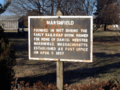
Historical marker on State Avenue
-
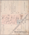
Map from 1877 Warren County Atlas
-
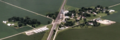
Aerial view looking to the southwest


See also
 In Spanish: Marshfield (Indiana) para niños
