Masatepe facts for kids
Quick facts for kids
Masatepe
Matapalete or Popocatepetl
|
||
|---|---|---|
|
Municipality
|
||
| Masatepe | ||
|
||
| Country | ||
| Department | Masaya | |
| Area | ||
| • Municipality | 22.9 sq mi (59.4 km2) | |
| Elevation | 1,558 ft (475 m) | |
| Population
(2022 estimate)
|
||
| • Municipality | 41,809 | |
| • Density | 1,823.0/sq mi (703.9/km2) | |
| • Urban | 22,978 | |
| Area code(s) | 42600 | |
| Climate | Aw | |
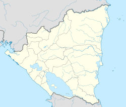
Masatepe (pronounced masa-TEH-peh) is a town in Nicaragua. It's one of nine towns in the Masaya Department. You can find it about 50 kilometers (about 31 miles) from Managua, the capital city.
Masatepe is part of a special area called "Los Pueblos Blancos" (The White Towns). These towns are known for their beautiful white buildings. The name "Masatepe" comes from an old language called Nahuatl. It means "Deer Mountain" or "Populated Deer." This name was given by the Nicarao people, who still live in the area. They are very good at growing cocoa.
History of Masatepe
The original name for Masatepe was Mazatepetl. This also means "Deer Mountain" in Nahuatl. Some old records also show names like Matapalete or Popocatepetl. These names mean "Burning Hill."
The first people to live here were the Chorotega. They settled near the Masaya Volcano. Later, they moved to areas called Nimboja and Jalapa.
In the past, a friar named Francisco de Bobadilla visited Matapalete. This was between 1528 and 1529. He counted 154 native people living there. In 1613, a historian named Fray Juan Torquemada wrote about Masatepe as a town.
During the modern era, in 1835, Nicaragua had only four departments. Masatepe was part of the Granada Department back then.
Weather and Location
Masatepe is located on a high area called the Plateau of Towns. It sits about 475 meters (1,558 feet) above sea level. The area has two main types of natural environments:
- Rainforest: This part has native trees and coffee farms. It's usually found at higher elevations (400-500 meters).
- Dry Valley: This area is closer to the Masaya Lagoon and the Masaya Volcano. It's at lower elevations (90-250 meters).
The temperature in Masatepe changes throughout the year. It's mostly warm. During the cooler months, from November to January, the mornings can be foggy.
| Climate data for Masatepe (1971–1990) | |||||||||||||
|---|---|---|---|---|---|---|---|---|---|---|---|---|---|
| Month | Jan | Feb | Mar | Apr | May | Jun | Jul | Aug | Sep | Oct | Nov | Dec | Year |
| Mean daily maximum °C (°F) | 27.4 (81.3) |
28.4 (83.1) |
30.1 (86.2) |
31.1 (88.0) |
30.5 (86.9) |
28.4 (83.1) |
27.7 (81.9) |
28.2 (82.8) |
28.7 (83.7) |
27.8 (82.0) |
27.4 (81.3) |
27.0 (80.6) |
28.6 (83.5) |
| Daily mean °C (°F) | 23.1 (73.6) |
23.7 (74.7) |
24.9 (76.8) |
25.8 (78.4) |
25.9 (78.6) |
24.0 (75.2) |
24.4 (75.9) |
24.6 (76.3) |
24.5 (76.1) |
24.1 (75.4) |
23.7 (74.7) |
23.2 (73.8) |
24.3 (75.7) |
| Mean daily minimum °C (°F) | 18.8 (65.8) |
18.9 (66.0) |
18.4 (65.1) |
20.4 (68.7) |
21.1 (70.0) |
21.0 (69.8) |
20.0 (68.0) |
20.9 (69.6) |
20.7 (69.3) |
20.4 (68.7) |
20.4 (68.7) |
19.4 (66.9) |
20.0 (68.0) |
| Average precipitation mm (inches) | 12 (0.5) |
10 (0.4) |
5 (0.2) |
17 (0.7) |
203 (8.0) |
185 (7.3) |
141 (5.6) |
172 (6.8) |
273 (10.7) |
239 (9.4) |
84 (3.3) |
29 (1.1) |
1,370 (53.9) |
| Average precipitation days (≥ 1.0 mm) | 4 | 1 | 1 | 2 | 11 | 18 | 17 | 17 | 18 | 19 | 10 | 7 | 124 |
| Source: National Oceanic and Atmospheric Administration | |||||||||||||
Sports
Masatepe is home to a football (soccer) team. The team is called Deportivo Masatepe.
See also
 In Spanish: Masatepe para niños
 | Selma Burke |
 | Pauline Powell Burns |
 | Frederick J. Brown |
 | Robert Blackburn |


