
Mata de Plátano facts for kids
Quick facts for kids
Mata de Plátano
|
|
|---|---|
|
Barrio
|
|

Main road in Mata de Plátano
|
|

Location of Mata de Plátano within the municipality of Luquillo shown in red
|
|
| Lua error in Module:Location_map at line 416: Malformed coordinates value. | |
| Commonwealth | |
| Municipality | |
| Area | |
| • Total | 5.19 sq mi (13.4 km2) |
| • Land | 4.49 sq mi (11.6 km2) |
| • Water | 0.70 sq mi (1.8 km2) |
| Elevation | 20 ft (6 m) |
| Population
(2010)
|
|
| • Total | 8,972 |
| • Density | 1,998.2/sq mi (771.5/km2) |
| Source: 2010 Census | |
| Time zone | UTC−4 (AST) |
Mata de Plátano is a special kind of neighborhood called a barrio in the sunny island of Puerto Rico. It's located within the larger area known as Luquillo, Puerto Rico. In 2010, about 8,972 people called Mata de Plátano home. It's a vibrant community with its own unique charm.
About Mata de Plátano
Mata de Plátano is part of the municipality of Luquillo, which is on the northeastern coast of Puerto Rico. A "barrio" is like a district or a neighborhood, and Puerto Rico is divided into many of these. Mata de Plátano covers an area of about 5.19 square miles, with most of it being land.
Population Changes Over Time
The number of people living in Mata de Plátano has grown quite a bit over the years. This information comes from the U.S. Census, which counts people every ten years.
| Historical population | |||
|---|---|---|---|
| Census | Pop. | %± | |
| 1980 | 5,447 | — | |
| 1990 | 6,783 | 24.5% | |
| 2000 | 8,318 | 22.6% | |
| 2010 | 8,972 | 7.9% | |
| U.S. Decennial Census 1899 (shown as 1900) 1910-1930 1930-1950 1980-2000 2010 |
|||
As you can see from the chart, the population has steadily increased since 1980. This shows that more and more people are choosing to live in this area.
Images for kids
-
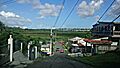
The main road in Mata de Plátano, showing a view of the area.
-
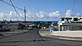
A street view in Mata de Plátano barrio, with a glimpse of the ocean.

See also
- List of communities in Puerto Rico
- In Spanish:
 Mata de Plátano (Luquillo) para niños
