Matthews, Georgia facts for kids
Quick facts for kids
Matthews, Georgia
|
|
|---|---|
| Country | United States |
| State | Georgia |
| County | Jefferson |
| Area | |
| • Total | 3.53 sq mi (9.15 km2) |
| • Land | 3.52 sq mi (9.12 km2) |
| • Water | 0.01 sq mi (0.03 km2) |
| Elevation | 390 ft (120 m) |
| Population
(2020)
|
|
| • Total | 146 |
| • Density | 41.47/sq mi (16.01/km2) |
| Time zone | UTC-5 (Eastern (EST)) |
| • Summer (DST) | UTC-4 (EDT) |
| ZIP code |
30818
|
| Area code(s) | 706 |
| GNIS feature ID | 332331 |
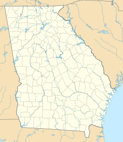
Matthews is a small place in Jefferson County, Georgia, USA. It's known as a census-designated place (CDP) and an unincorporated community. This means it's a recognized area for counting people, but it doesn't have its own local government like a city or town. In 2020, about 146 people lived there. A road called Georgia State Route 88 goes right through Matthews.
People Living in Matthews
Matthews is a quiet community with a small number of residents. The number of people living here has stayed pretty steady over the years.
| Historical population | |||
|---|---|---|---|
| Census | Pop. | %± | |
| 2010 | 150 | — | |
| 2020 | 146 | −2.7% | |
| 1980-2000 2010 2020 |
|||
Matthews was first officially counted as a census-designated place in the 2010 U.S. Census. This is how the government keeps track of populations in smaller areas that aren't formal cities or towns.
See also
 In Spanish: Matthews (Georgia) para niños
Black History Month on Kiddle
Famous African-American Inventors:
 | George Robert Carruthers |
 | Patricia Bath |
 | Jan Ernst Matzeliger |
 | Alexander Miles |

All content from Kiddle encyclopedia articles (including the article images and facts) can be freely used under Attribution-ShareAlike license, unless stated otherwise. Cite this article:
Matthews, Georgia Facts for Kids. Kiddle Encyclopedia.


