Matty Island facts for kids

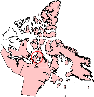
Matty Island, Nunavut.
|
|
| Geography | |
|---|---|
| Location | Rae Strait |
| Coordinates | 69°29′N 95°40′W / 69.483°N 95.667°W |
| Archipelago | Canadian Arctic Archipelago |
| Area | 477 km2 (184 sq mi) |
| Administration | |
| Territory | Nunavut |
| Region | Kitikmeot |
| Demographics | |
| Population | Uninhabited |
Matty Island is a cool island located in the Canadian Arctic. It is part of the Kitikmeot Region in Nunavut, Canada. This island is found in the Rae Strait, a narrow body of water.
About Matty Island
Matty Island is one of many islands in the vast Canadian Arctic. It is known for being uninhabited, meaning no people live there permanently. The island covers an area of about 477 square kilometers. That's a lot of space, but it's mostly wild and untouched.
Where is Matty Island?
This island is located between two important landmasses. To its west is King William Island, and to its east is the Boothia Peninsula. These are both significant parts of the Canadian Arctic landscape.
Other islands are also nearby. To the south, you can find the Beverly Islands. To the west, there are the Tennent Islands. These islands are all part of the same cold, northern region.
See also
 In Spanish: Isla Matty para niños
 | Roy Wilkins |
 | John Lewis |
 | Linda Carol Brown |


