
Maugherow Peninsula facts for kids
|
Machaire Eabha
|
|
|---|---|

Maugherow Peninsula (Red) within County Sligo
|
|
| Geography | |
| Location | Ireland |
| Adjacent bodies of water | |
| Area | 57.2 km2 (22.1 sq mi) |
| Administration | |
| County | Sligo |
| Demographics | |
| Population | 3,105 (2016) |
| Pop. density | 54.3 /km2 (140.6 /sq mi) |
The Maugherow Peninsula is a large piece of land in County Sligo, Ireland. It sticks out into the Atlantic Ocean. This area is also sometimes called the Raghly Peninsula. This name comes from Raghly Point, which is a smaller piece of land sticking out from the peninsula.
The Maugherow Peninsula forms the northern edge of Sligo Bay. It has a rough coastline because it faces the open ocean. This makes it less popular for tourists compared to other peninsulas in Sligo. Some of these other popular spots include Mullaghmore, Rosses Point, and Coolera.
Most of the Maugherow Peninsula is flat and used for farming. Houses are often built in a line along the roads. The only main village on the peninsula is Carney. A larger town called Grange is located nearby, on the edge of the peninsula.
Cool Places to Visit
The Maugherow Peninsula has some interesting spots to explore. Here are a few:
- Ballygilgan Nature Reserve: This is a special place where you can see lots of wildlife. It's great for nature lovers.
- Lissadell House: This is a famous old house with beautiful gardens. It has a lot of history.
- Knocklane Fort: This is an ancient fort. It shows how people lived and protected themselves long ago.
- Raghly Harbour: A small, pretty harbour where boats can dock. It's a nice spot to watch the water.
- Streedagh Armada wrecksite: This is where ships from the Spanish Armada sank many years ago. It's a very important historical site.
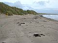
- Streedagh Beach: A long, sandy beach. It's perfect for walks and enjoying the sea air.
- Yellow Strand Beach: Another lovely beach in the area. It's known for its golden sand.
Gallery
-
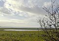
Barnacle Geese at Ballygilgan Nature Reserve
-
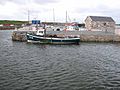
Boats at Raghly Harbour
-
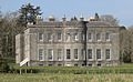
Lissadell House
-
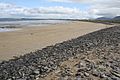
Streedagh Beach
-
Yellow Strand Beach


_-_geograph.org.uk_-_978000.jpg)
