Maxton, North Carolina facts for kids
Quick facts for kids
Maxton, North Carolina
|
|
|---|---|

Maxton, North Carolina
|
|
| Country | United States |
| State | North Carolina |
| Counties | Robeson, Scotland |
| Incorporated | 1874 |
| Government | |
| • Type | Town Council |
| Area | |
| • Total | 2.70 sq mi (6.99 km2) |
| • Land | 2.70 sq mi (6.99 km2) |
| • Water | 0.00 sq mi (0.00 km2) |
| Elevation | 197 ft (60 m) |
| Population
(2020)
|
|
| • Total | 2,110 |
| • Density | 782.06/sq mi (301.94/km2) |
| Time zone | UTC-5 (Eastern (EST)) |
| • Summer (DST) | UTC-4 (EDT) |
| ZIP code |
28364
|
| Area codes | 910, 472 |
| FIPS code | 37-42020 |
| GNIS feature ID | 2406111 |
Maxton is a town located in Robeson and Scotland counties, North Carolina, United States. In 2020, about 2,110 people lived there.
Contents
History of Maxton
The Maxton area was first settled in the 1700s. The community officially became a town in 1874. It was first called Shoe Heel.
The town's name changed to Tilden in honor of Samuel J. Tilden, who ran for U.S. President in 1876. In 1881, the name went back to Shoe Heel. Finally, in 1887, the town was named Maxton.
In the 1960s, farming changed, and Maxton's role as a local market town became less important. The town was far from major highways like Interstate 95. This meant fewer new businesses came, and the economy slowed down. By 2000, Maxton became a town where most people were Black. A new town government with many Black officials started to include more older Black neighborhoods within the town's official borders. In 2004, a new highway was built around the town. This meant travelers no longer stopped in Maxton, which affected local businesses.
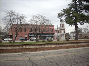
The Maxton Historic District is a special area in town. It was added to the National Register of Historic Places in 1999. This means it has important historical buildings and places.
Schools and Colleges in Maxton
Maxton has been home to several important schools over the years.
- Flora MacDonald College started in 1841. It was the first college in North Carolina to allow women to earn degrees.
- Charles N. Hunter, a famous African-American educator, opened his first school in Maxton. He later started the North Carolina Industrial Association.
- Carolina College was a college for women. It was run by the Methodist church and operated in Maxton from 1912 to 1926.
- Carolina Military Academy was a military school for boys. It taught students from 7th to 12th grade and beyond. The school was in Maxton from 1963 to 1972. In its last years, it also allowed girls to attend as day students.
The Battle of Hayes Pond
In January 1958, the Ku Klux Klan, a hate group, burned crosses at the homes of two Lumbee families. A few nights later, on January 18, 1958, the Lumbee people took action. They surrounded a public Klan meeting near Maxton. The Lumbee people broke up the meeting, and the Klan members had to leave. Some left with police help, while others ran into the woods.
This event made national news. The Klan never held another public meeting in Robeson County after that day. The Lumbee people call this event the Battle of Hayes Pond. They celebrate it as an important holiday.
Geography of Maxton
According to the United States Census Bureau, the town of Maxton covers about 2.7 square miles (6.99 square kilometers). All of this area is land.
Population and People
| Historical population | |||
|---|---|---|---|
| Census | Pop. | %± | |
| 1890 | 694 | — | |
| 1900 | 935 | 34.7% | |
| 1910 | 1,321 | 41.3% | |
| 1920 | 1,397 | 5.8% | |
| 1930 | 1,386 | −0.8% | |
| 1940 | 1,656 | 19.5% | |
| 1950 | 1,974 | 19.2% | |
| 1960 | 1,755 | −11.1% | |
| 1970 | 1,885 | 7.4% | |
| 1980 | 2,711 | 43.8% | |
| 1990 | 2,373 | −12.5% | |
| 2000 | 2,551 | 7.5% | |
| 2010 | 2,426 | −4.9% | |
| 2020 | 2,110 | −13.0% | |
| U.S. Decennial Census | |||
Maxton's Population in 2020
| Race | Num. | Perc. |
|---|---|---|
| White (non-Hispanic) | 357 | 16.92% |
| Black or African American (non-Hispanic) | 1,287 | 61.0% |
| Native American | 352 | 16.68% |
| Asian | 9 | 0.43% |
| Pacific Islander | 1 | 0.05% |
| Other/Mixed | 73 | 3.46% |
| Hispanic or Latino | 31 | 1.47% |
In 2020, there were 2,110 people living in Maxton. There were 1,006 households and 644 families.
Famous People from Maxton
- Allen LaGrant "Mickey" Bowers (born 1949) is a retired professional baseball player, scout, coach, and manager.
- Effie Neal Jones (1919–2002) was a civil rights activist. She also worked as a Food Services Director and Counselor.
- Angus McLean (1870–1935) was the Governor of North Carolina from 1924 to 1928.
- Malcolm ("Malcom") McLean (1913–2001) was a trucking industry leader. He is known as the "father of containerization" for his ideas on shipping goods.
- Gilbert Brown Patterson (1863–1922) was a politician. He was a member of the United States House of Representatives from North Carolina.
- Alice B. Russell (1892–1984) was a singer and actress. She was married to Oscar Micheaux.
See also
 In Spanish: Maxton para niños
 | Bayard Rustin |
 | Jeannette Carter |
 | Jeremiah A. Brown |


