McElhattan, Pennsylvania facts for kids
Quick facts for kids
McElhattan, Pennsylvania
|
|
|---|---|

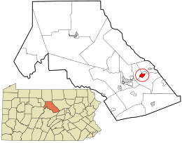
Location in Clinton County and the state of Pennsylvania.
|
|
| Country | United States |
| State | Pennsylvania |
| County | Clinton |
| Township | Wayne |
| Area | |
| • Total | 3.48 sq mi (9.02 km2) |
| • Land | 3.35 sq mi (8.67 km2) |
| • Water | 0.14 sq mi (0.35 km2) |
| Elevation | 577 ft (176 m) |
| Population
(2020)
|
|
| • Total | 1,224 |
| • Density | 365.81/sq mi (141.24/km2) |
| Time zone | UTC-5 (Eastern (EST)) |
| • Summer (DST) | UTC-4 (EDT) |
| ZIP code |
17748
|
| FIPS code | 42-46112 |
| GNIS feature ID | 1180705 |
McElhattan is a small community located in Wayne Township in Clinton County, Pennsylvania, United States. It is known as a census-designated place (CDP). This means it's an area the U.S. Census Bureau identifies for gathering statistics. It does not have its own local government like a city or town.
Contents
Where is McElhattan located?
McElhattan is in the eastern part of Clinton County. It sits next to the West Branch of the Susquehanna River on its northwest side. To the southeast, you'll find U.S. Route 220, which is a four-lane highway.
Nearby places
The southwestern part of McElhattan includes an area called Youngdale. If you travel west on US 220 for about 6 miles (10 km), you will reach Lock Haven. Lock Haven is the main town, or county seat, of Clinton County. Going northeast on US 220 for about 7 miles (11 km) will take you to the borough of Jersey Shore.
Crossing the river
There is also a road called Bridge Road. This road crosses the West Branch of the Susquehanna River. It connects McElhattan with Dunnstable Township, which is located to the northwest.
How many people live in McElhattan?
| Historical population | |||
|---|---|---|---|
| Census | Pop. | %± | |
| 2020 | 1,224 | — | |
| U.S. Decennial Census | |||
According to the 2020 census, about 1,224 people live in McElhattan. In 2010, the population was 598. This shows that the community has grown over the past decade.
See also
 In Spanish: McElhattan para niños

