Melville, Rhode Island facts for kids
Quick facts for kids
Melville, Rhode Island
|
|
|---|---|

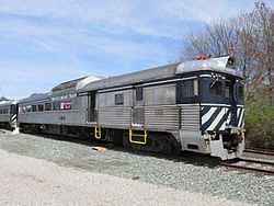
The Ice Cream Train
|
|
| Country | United States |
| State | Rhode Island |
| County | Newport |
| Area | |
| • Total | 5.13 sq mi (13.29 km2) |
| • Land | 2.10 sq mi (5.43 km2) |
| • Water | 3.03 sq mi (7.85 km2) |
| Elevation | 36 ft (11 m) |
| Population
(2020)
|
|
| • Total | 1,609 |
| • Density | 766.92/sq mi (296.12/km2) |
| Time zone | UTC-5 (Eastern (EST)) |
| • Summer (DST) | UTC-4 (EDT) |
| FIPS code | 44-45010 |
| GNIS feature ID | 2378109 |
Melville is a special kind of community called a census-designated place (CDP). It is located in the towns of Middletown and Portsmouth. These towns are in Newport County, Rhode Island, in the United States. Melville sits right on the shore of Narragansett Bay.
In 2020, about 1,609 people lived here. The area is named after Admiral George Wallace Melville. In the past, it was known by other names like Portsmouth Grove and Bradford.
Contents
Melville's Military Past
Melville has an interesting history with the military.
Civil War Hospital
During the American Civil War, Melville was home to the Lovell General Hospital. This hospital helped many soldiers.
Later, in the late 1800s, the U.S. Navy built a coaling station in Melville. This was a place where Navy ships could get coal for their engines. It was later changed into a fuel oil depot.
World War II Training Center
During World War II, Melville became a very important training center. It was called the Motor Torpedo Boat Squadrons Training Center. Here, officers learned how to operate PT boats. A famous person who trained here was John F. Kennedy, who later became the President of the United States. The center closed after the war ended.
After the Navy left Melville in 1973, the area was turned into a boat yard. Today, the Navy still uses some land in Melville for housing and fun activities for its personnel.
Melville's Geography
Melville covers a total area of about 13.1 square kilometers (5.1 square miles). Most of this area is water, about 7.5 square kilometers (2.9 square miles). The land area is about 5.6 square kilometers (2.2 square miles).
Cool Places to See in Melville
Melville has several interesting spots:
- Dyer Island: This is an island that no one lives on.
- Melville Marina District: Also known as Bend Boat Basin, this is a great place for boats. You can find it at Coggeshall Point.
- Melville Park: This park is near a group of ponds. You can also find Melville Ponds Campground and Portsmouth Dog Park here.
- N&NB Railroad Melville Station: This is also called Portsmouth Junction Station. It's the main office for the Rhode Island part of Rail Explorers, where you can ride special rail bikes.
- Naval Station Newport: Some parts of this Navy base, including the Naval Undersea Warfare Center, are located within Melville.
Who Lives in Melville?
Population in 2020
The 2020 United States census counted 1,609 people living in Melville. There were 514 households and 494 families.
Most people in Melville are white (about 66%). There are also people who identify as black or African-American (about 9%), Asian (about 6%), and other races. About 14% of the population is Hispanic or Latino.
Many households (61.5%) have children under 18. Most families (70.6%) are married couples living together. The average household has about 3.2 people.
The median age in Melville is about 28.6 years old. This means half the people are younger than 28.6, and half are older. About 35% of the population is under 18 years old.
See also
 In Spanish: Melville (Rhode Island) para niños
 | William Lucy |
 | Charles Hayes |
 | Cleveland Robinson |


