Mercury Islands facts for kids
|
Iles d'Haussez
|
|
|---|---|
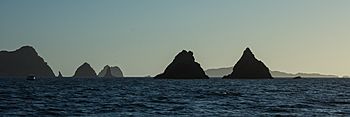
View of the Mercury Islands
|
|
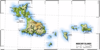
Topographic map of the Mercury Islands
|
|
| Geography | |
| Coordinates | 36°35′S 175°55′E / 36.583°S 175.917°E |
| Adjacent bodies of water | South Pacific Ocean |
| Total islands | 16 |
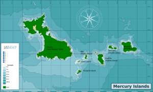
| Major islands | Great Mercury Island (Ahuahu), Red Mercury Island (Whakau), Double Island (Moturehu), Kawhitu or Stanley Island, Ātiu or Middle Island, Korapuki Island |
| Administration | |
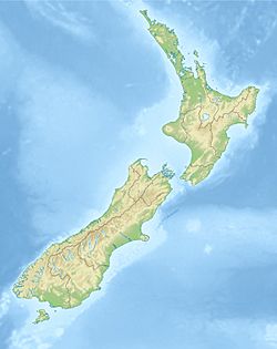
The Mercury Islands are a group of seven islands located off the northeast coast of New Zealand's North Island. They are about 8 kilometers (5 miles) from the Coromandel Peninsula and 35 kilometers (22 miles) northeast of the town of Whitianga. These islands are a special place, known for their unique wildlife and interesting history.
Contents
History of the Mercury Islands
The Mercury Islands have a long history. The Ngāti Hei people and a group called Ngāti Karaua lived on these islands since the 14th century.
In 1839, a European settler claimed to have bought Great Mercury Island. Later, between 1858 and 1865, Great Mercury Island (Ahuahu), Kawhitu or Stanley Island, and Double Island (Moturehu) were bought and became crown land. The Ngāti Hei people, who lived on Ahuahu, were not asked about this purchase.
In 2017, the New Zealand government and the Ngāti Hei people reached an agreement. This agreement officially recognized that the Ngāti Hei have a strong connection and claim to Great Mercury Island.
Exploring the Mercury Islands
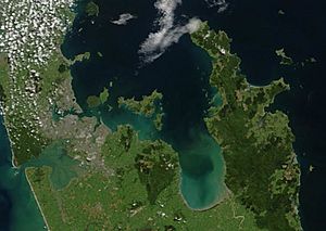
The main group of Mercury Islands includes the large Great Mercury Island (also called Ahuahu) to the west. To the east is Red Mercury Island (Whakau). Between these two are five smaller islands: Korapuki, Green, Atiu/Middle, Kawhitu/Stanley, and Moturehu/Double Islands.
All the islands, except Ahuahu/Great Mercury Island, are protected. They are managed by the Department of Conservation as important Nature Reserves. This means that public access is usually not allowed to protect the plants and animals.
Ahuahu/Great Mercury Island is privately owned, but people can visit most parts of it. There is one more island, Repanga/Cuvier Island, which is about 15 kilometers (9 miles) north of Ahuahu. It is also a protected Nature Reserve, but it is not usually considered part of the Mercury Island group.
How the Islands Formed
About 18,000 years ago, during the Last Glacial Maximum (a very cold period), sea levels were much lower. The Mercury Islands were actually hills on a large coastal plain. As the Earth warmed, sea levels began to rise about 7,000 years ago. This caused the land around the hills to flood, turning them into the islands we see today. Back when sea levels were lower, the Opitonui River flowed into the Pacific Ocean between Cuvier Island and Ahuahu/Great Mercury Island.
Ahuahu / Great Mercury Island
Ahuahu / Great Mercury Island is the biggest of the Mercury Islands, covering 1,872 hectares (about 4,626 acres). It is the only island in the group with people living on it permanently, and it is also the only one where the public can visit. This island is what is left of an ancient rhyolitic volcano.
Before New Zealand became a colony, the island had at least 20 pā (fortified Māori villages). One important pā was Matakawau, on the western side of the island. People have studied this site to learn about its past. In the late 1800s, people also dug for kauri gum on the island.
The island is currently owned by two New Zealand businessmen, Michael Fay and David Richwhite. It has two fancy homes and can be rented for special events. Famous people like Bono and The Edge from the band U2 have stayed there. In 2009, Ahuahu/Great Mercury Island was also the site of the first successful launch of Rocket Lab's Atea-1 sounding rocket, which is a small rocket used for scientific research.
Protecting Wildlife on Ahuahu
In 2014, the owners worked with the Department of Conservation to remove pests from the island. They successfully got rid of kiore (Pacific rats), ship rats, and cats. By 2016, the island was declared pest-free! This means the entire Mercury Island Group is now free from these introduced mammal pests. Ahuahu remains open to the public to show how conservation works and to provide a safe, pest-free island for everyone to enjoy.
Whakau / Red Mercury Island
Whakau is the easternmost of the Mercury Islands and the second-largest, about 2.3 kilometers (1.4 miles) across. The island is surrounded by reddish cliffs that can be up to 100 meters (328 feet) high. This reddish color is why Captain James Cook named it Red Mercury Island when he explored the area in 1769.
During World War One, a German adventurer named Count Felix von Luckner briefly used a cove on the island's northern coast as a hiding spot. He was trying to escape from New Zealand. Like the other Mercury Islands, Whakau was formed by volcanic activity, and you can still see signs of this along its coast.
Other Important Islands
The smaller islands in the Mercury group are very important for birds. They are recognized as an Important Bird Area by BirdLife International. This is because they provide nesting sites for up to 3,000 pairs of Pycroft's petrels, a type of seabird.
Moturehu/Double Island and Whakau/Red Mercury are also home to a very rare insect called the Mercury Islands tusked wētā. This special wētā is critically endangered, making these islands vital for its survival.
 | Delilah Pierce |
 | Gordon Parks |
 | Augusta Savage |
 | Charles Ethan Porter |


