Meredith, Colorado facts for kids
Quick facts for kids
Meredith, Colorado
|
|
|---|---|

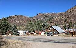
A view of Meredith from across Frying Pan Road
|
|
| Country | |
| State | |
| County | Pitkin |
| Elevation | 2,369 m (7,773 ft) |
| Time zone | UTC-7 (MST) |
| • Summer (DST) | UTC-6 (MDT) |
| ZIP code |
81642
|
| GNIS feature ID | 179732 |
Meredith is a small, quiet community located in Pitkin County, Colorado. It's known as an unincorporated community. This means it's a place where people live but doesn't have its own local government like a city or town. Instead, it's managed by the county. Meredith also has its own U.S. Post Office with the ZIP Code 81642.
Contents
Meredith's History
Meredith has an interesting past. In the 1890s, it was a busy place. It was a "limestone quarry town," where people dug out limestone. Limestone is a type of rock used for building and other things. Meredith was also a "lumber camp," meaning people worked there cutting down trees for wood. Today, many of the original buildings are still standing and people live in them. The area is now mainly a "resort area," which means it's a popular place for people to visit and relax.
Weather in Meredith
Meredith experiences a mountain climate. This means it has cold, snowy winters and warm, pleasant summers. The weather can change quickly, especially in the mountains.
Temperature Changes
In Meredith, temperatures can vary a lot throughout the year. Winter months, like January and February, are very cold. Average low temperatures can be in the single digits Fahrenheit. Summers, especially July and August, are much warmer. Average high temperatures can reach the low 80s Fahrenheit.
Rain and Snow
Meredith gets a good amount of precipitation. This includes both rain and snow. Winters bring heavy snowfall, making it a beautiful, white landscape. Spring and fall also see some snow. Summers tend to have less snow, but still get rain.
Detailed Weather Information
You can see more detailed weather information for Meredith in the box below. It shows average temperatures, record highs and lows, and how much rain and snow the area gets each month.
| Climate data for Meredith, Colorado, 1991–2020 normals: 7825ft (2385m) | |||||||||||||
|---|---|---|---|---|---|---|---|---|---|---|---|---|---|
| Month | Jan | Feb | Mar | Apr | May | Jun | Jul | Aug | Sep | Oct | Nov | Dec | Year |
| Record high °F (°C) | 58 (14) |
59 (15) |
65 (18) |
75 (24) |
89 (32) |
91 (33) |
98 (37) |
93 (34) |
90 (32) |
80 (27) |
68 (20) |
59 (15) |
98 (37) |
| Mean maximum °F (°C) | 48 (9) |
50 (10) |
56 (13) |
66 (19) |
76 (24) |
85 (29) |
89 (32) |
87 (31) |
83 (28) |
73 (23) |
60 (16) |
50 (10) |
92 (33) |
| Mean daily maximum °F (°C) | 34.1 (1.2) |
35.7 (2.1) |
42.9 (6.1) |
51.0 (10.6) |
62.9 (17.2) |
74.5 (23.6) |
81.1 (27.3) |
79.7 (26.5) |
71.2 (21.8) |
61.1 (16.2) |
44.6 (7.0) |
33.7 (0.9) |
56.0 (13.4) |
| Daily mean °F (°C) | 18.8 (−7.3) |
20.7 (−6.3) |
28.1 (−2.2) |
35.8 (2.1) |
45.6 (7.6) |
54.3 (12.4) |
60.4 (15.8) |
59.4 (15.2) |
51.6 (10.9) |
42.2 (5.7) |
28.9 (−1.7) |
19.2 (−7.1) |
38.7 (3.8) |
| Mean daily minimum °F (°C) | 3.5 (−15.8) |
5.7 (−14.6) |
13.2 (−10.4) |
20.6 (−6.3) |
28.4 (−2.0) |
34.1 (1.2) |
39.7 (4.3) |
39.1 (3.9) |
31.9 (−0.1) |
23.3 (−4.8) |
13.2 (−10.4) |
4.7 (−15.2) |
21.5 (−5.8) |
| Mean minimum °F (°C) | −17 (−27) |
−16 (−27) |
−7 (−22) |
7 (−14) |
17 (−8) |
25 (−4) |
31 (−1) |
31 (−1) |
21 (−6) |
11 (−12) |
−7 (−22) |
−15 (−26) |
−22 (−30) |
| Record low °F (°C) | −29 (−34) |
−38 (−39) |
−30 (−34) |
−7 (−22) |
6 (−14) |
17 (−8) |
23 (−5) |
23 (−5) |
12 (−11) |
−5 (−21) |
−21 (−29) |
−35 (−37) |
−38 (−39) |
| Average precipitation inches (mm) | 1.50 (38) |
1.57 (40) |
1.85 (47) |
2.15 (55) |
1.87 (47) |
1.05 (27) |
1.70 (43) |
1.65 (42) |
1.97 (50) |
1.71 (43) |
1.53 (39) |
1.15 (29) |
19.7 (500) |
| Average snowfall inches (cm) | 19.0 (48) |
14.6 (37) |
11.6 (29) |
7.7 (20) |
1.9 (4.8) |
0.0 (0.0) |
0.0 (0.0) |
0.0 (0.0) |
0.2 (0.51) |
3.4 (8.6) |
10.5 (27) |
19.1 (49) |
88 (223.91) |
| Source 1: NOAA | |||||||||||||
| Source 2: XMACIS (records & monthly max/mins & Basalt precip/snowfall) | |||||||||||||
 | Selma Burke |
 | Pauline Powell Burns |
 | Frederick J. Brown |
 | Robert Blackburn |


