
Merir facts for kids

Merir, also known as Melieli, is a small, quiet island in the western Pacific Ocean. It is part of the Palau group of islands. Merir is a long, narrow island, stretching about 2.4 kilometers (1.5 miles) from north to south. At its widest point, it is only about 667 meters (0.4 miles) across. The island covers an area of 0.90 square kilometers (0.35 square miles).
Merir is not currently home to any people. There is an old, empty village in the northwest part of the island. This village once had a radio station.
Island Features
Merir Island is covered with many trees. Around the island, you will find a beautiful beach. Beyond the beach is a calm body of water called a lagoon. Outside the lagoon, a coral reef surrounds the entire island, protecting it from the open ocean.
Where is Merir?
Merir is part of the state of Sonsorol in the Republic of Palau. It is located near other islands. Sonsorol and Fana islands are about 110 kilometers (68 miles) to the northwest. The island of Pulo Anna is about 50 kilometers (31 miles) away. These islands together form the state of Sonsorol.
Island History
The first time Europeans saw Merir was in November 1710. A Spanish group led by a missionary named Francisco Padilla discovered the island. They were traveling on a ship called the Santísima Trinidad.
Images for kids
-
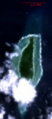
Satellite view of the Island of Merir
-
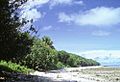
Lush plants and a beach scene on western Merir
-
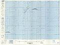
Map showing Merir (from the Defense Mapping Agency, 1991)


See also
 In Spanish: Merir para niños
