
Middlefield–Becket Stone Arch Railroad Bridge District facts for kids
Quick facts for kids |
|
|
Middlefield–Becket Stone Arch Railroad Bridge District
|
|

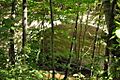
Near Middlefield Road in Chester
|
|

Location in Massachusetts

Location in the United States
|
|
| Nearest city | Chester, Massachusetts |
|---|---|
| Built | 1840 |
| Architect | George Washington Whistler |
| NRHP reference No. | 80000502 |
| Added to NRHP | April 11, 1980 |
The Middlefield–Becket Stone Arch Railroad Bridge District is a special area in Massachusetts. It has many old and important railroad bridges. This district stretches through parts of Chester, Middlefield, and Becket, Massachusetts.
There are ten bridges along a 3.7-mile (6 km) stretch of railroad tracks. Nine of these bridges cross the west branch of the Westfield River. These bridges were built at different times. Some were built in 1840, others in 1866, 1912, and 1928. Most of them are made of stone or concrete. One bridge is a steel truss girder bridge. All the bridges are in great shape, almost like new.
These bridges were built for the Western Railroad. They helped trains travel from the Connecticut River to the Hudson River. Building this part of the railroad was very expensive. It cost over $1 million in 1840, which was a huge amount of money back then!
Contents
Who Built the Bridges?
The first bridges, built in 1840, were designed by George Washington Whistler. His team, Alexander Birney's company, built them. Out of the nine original stone bridges, only three are still standing today. These three are no longer used by trains.
Some of the old bridges were either torn down or covered in concrete. This happened during construction work in 1912 and 1927. One bridge was completely removed in 1927.
Newer Bridges and Their Materials
One of the bridges, number 4, was built in 1912. It is made of concrete. It stands next to an older stone bridge (number 3) from 1840 that was taken out of service. The only steel truss bridge in the district was also built in 1912. It was made by the Pennsylvania Steel Company.
This bridge district was added to the National Register of Historic Places in 1980. This means it is recognized as an important historical site.
Visiting the Bridges
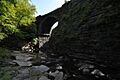
You can visit these historic bridges! A hiking trail was opened in 2004. This trail lets you see the lower seven bridges up close. If you like water sports, you can also see all the bridges from the river. Just make sure you use a boat that is safe for whitewater.
Bridge List
This table shows details about each bridge in the district. Most of these bridges were still in use in 1980. They mostly cross the West Branch Westfield River, unless noted otherwise.
| # | CSX Bridge # |
Image | Year built | Location | Description |
|---|---|---|---|---|---|
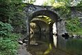
| 1 | 128.21 |  |
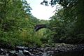
1866 | 42°18′45.6″N 72°59′38.3″W / 42.312667°N 72.993972°W | A stone arch bridge with two spans. |
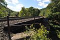
| 2 | 128.44 |  |
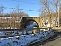
1912 | 42°18′50.8″N 72°59′52.3″W / 42.314111°N 72.997861°W | A steel bridge with a flat deck. |
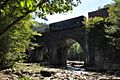
| 3 | out of service |  |
1840-41 | 42°18′35.8″N 73°00′10.4″W / 42.309944°N 73.002889°W | An old stone arch bridge. It stopped being used in 1912. |
| 4 | 129.28 |  |
1913 | 42°18′35.7″N 73°00′11.4″W / 42.309917°N 73.003167°W | A concrete arch bridge. |
| 5 | out of service |  |
1840-41 | 42°18′20.3″N 73°00′19.0″W / 42.305639°N 73.005278°W | A stone arch bridge. |
| 6 | out of service |  |
1840-41 | 42°18′31.8″N 73°00′51.3″W / 42.308833°N 73.014250°W | A stone arch bridge. |
| 7 | 130.10 |  |
1912 | 42°18′33.2″N 73°01′04.8″W / 42.309222°N 73.018000°W | A concrete arch bridge. |
| 8 | 130.46 |  |
1866/1912 | 42°18′36.2″N 73°01′29.7″W / 42.310056°N 73.024917°W | A stone and concrete arch bridge. It crosses Factory Brook and Town Hill Road. |
| 9 | 131.50 | 1928 | 42°19′05.9″N 73°02′22.7″W / 42.318306°N 73.039639°W | A concrete arch bridge. | |
| 10 | 131.70 | 1928 | 42°19′11.6″N 73°02′34.6″W / 42.319889°N 73.042944°W | A concrete arch bridge. |
Images for kids
-
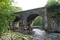
Near Middlefield Road in Chester
-
Bridge #1
-
Bridge #2
-
Bridge #3
-
Bridge #4
-
Bridge #5
-
Bridge #6
-

Bridge #7
-
Bridge #8
