Mier, Indiana facts for kids
Quick facts for kids
Mier, Indiana
|
|
|---|---|

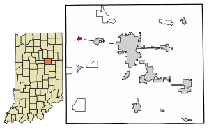
Location of Mier in Grant County, Indiana.
|
|
| Country | United States |
| State | Indiana |
| County | Grant |
| Township | Richland |
| Area | |
| • Total | 0.24 sq mi (0.62 km2) |
| • Land | 0.24 sq mi (0.62 km2) |
| • Water | 0.00 sq mi (0.00 km2) |
| Elevation | 833 ft (254 m) |
| Population
(2020)
|
|
| • Total | 67 |
| • Density | 280.33/sq mi (108.12/km2) |
| ZIP code |
46919
|
| Area code(s) | 765 |
| FIPS code | 18-49212 |
| GNIS feature ID | 2583459 |
Mier is a small place in Grant County, Indiana, in the United States. It's called an "unincorporated community" and a "census-designated place" (CDP). This means it's a recognized area for counting people, but it doesn't have its own local government like a city or town. In 2010, about 78 people lived there.
Contents
A Look Back at Mier's History
Mier got its name from a place in Mexico called Ciudad Mier. It's interesting how places can be named after others far away!
When Mier Had a Post Office
A post office was opened in Mier way back in 1849. It helped people send and receive letters and packages. The post office stayed open for many years. However, it closed down in 1928.
Where is Mier Located?
Mier is found in the northwestern part of Grant County. Several important roads pass through it. These include State Road 13, State Road 18, and State Road 19.
Traveling Around Mier
State Road 18 can take you east about 3 miles (5 km) to a town called Sweetser. If you head west on State Road 18, you'll reach Converse in about 2.5 miles (4 km).
State Road 13 goes north about 6.5 miles (10.5 km) to Somerset. If you drive south on State Road 13, you'll get to Swayzee in about 4.5 miles (7 km).
State Road 19 follows State Road 13 when going south from Mier. It also follows State Road 18 when going west from Mier. Marion, which is the main city of Grant County, is about 9 miles (14.5 km) east of Mier on State Road 18.
Mier's Size
According to the U.S. Census Bureau, the Mier CDP covers an area of about 0.6 square kilometers (0.24 square miles). All of this area is land, meaning there are no large bodies of water within its boundaries.
Who Lives in Mier?
| Historical population | |||
|---|---|---|---|
| Census | Pop. | %± | |
| 2020 | 67 | — | |
| U.S. Decennial Census | |||
The word "demographics" helps us understand the people who live in a place. It looks at things like population numbers.
Mier's Population
In the year 2020, the population of Mier was 67 people. This number helps us see how many residents call Mier home.
See also
 In Spanish: Mier (Indiana) para niños
 | Madam C. J. Walker |
 | Janet Emerson Bashen |
 | Annie Turnbo Malone |
 | Maggie L. Walker |


