Migues facts for kids
Quick facts for kids
Migues
|
|
|---|---|
|
City & Municipality
|
|
| Country | |
| Department | |
| Population
(2011 Census)
|
|
| • Total | 2,109 |
| Time zone | UTC -3 |
| Postal code |
91004
|
| Dial plan | +598 4317 (+4 digits) |
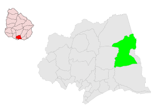
Migues is a small city located in the southern part of Uruguay, in the Canelones Department. The name Migues also refers to the larger area, or municipality, that includes the city.
Contents
About Migues
Where is Migues Located?
Migues is easy to find on a map! It sits where several roads meet: Route 80, Route 81, Route 88, and Route 108. It's about 22 kilometers (about 13.5 miles) southeast of a town called Tala. Migues is also about 6.5 kilometers (about 4 miles) west of Montes.
How Migues Grew
The story of Migues began on June 27, 1870. A village called "Carmen" was created on land owned by Nicasia Figueredo de Migues. This land was located between two streams of the Solís river. This village is likely the same one that later became known as Migues.
Over time, the village grew. On May 15, 1925, it was officially recognized as a "Villa," which means a town. Then, on June 26, 1970, Migues reached an even higher status. It was officially declared a "Ciudad," meaning a city.
Population of Migues
In 2011, a census counted the number of people living in Migues. At that time, the city had a population of 2,109 residents.
The local government, called the Intendencia de Canelones, estimated a larger population for the entire municipality of Migues. In 2010, they estimated about 3,720 people lived in the wider area during elections.
Here's how the population of Migues has changed over the years:
| Year | Population |
|---|---|
| 1908 | 5,000 |
| 1963 | 1,968 |
| 1975 | 2,183 |
| 1985 | 2,079 |
| 1996 | 2,004 |
| 2004 | 2,180 |
| 2011 | 2,109 |
Source: Instituto Nacional de Estadística de Uruguay
Important Places
Places of Worship
- Parish Church of Our Lady of Mt. Carmel (This is a Roman Catholic church.)
See also
 In Spanish: Migues para niños
 | Valerie Thomas |
 | Frederick McKinley Jones |
 | George Edward Alcorn Jr. |
 | Thomas Mensah |


