
Milecastle 22 facts for kids
Quick facts for kids Milecastle 22 |
|
|---|---|
| Northumberland, England, UK | |
_Milecastle_22_(Portgate)_-_geograph.org.uk_-_1234711.jpg)
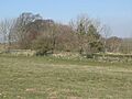
The site of Milecastle 22
|
|

Milecastle 22
Location in Northumberland
|
|
| Coordinates | 55°00′43″N 2°01′04″W / 55.012062°N 2.017702°W |
Milecastle 22 (Portgate) was a small fort, or milecastle, built by the Romans as part of Hadrian's Wall. Today, you can still see its remains as a low, grassy mound. This mound is just east of the Portgate roundabout, where the A68 and B6318 roads meet. On its east side, the mound is about 0.5 metres (1.6 ft) high. On the west side, it's mostly just a faint mark on the ground.
Contents
Building Milecastle 22
Milecastle 22 was designed with its longer side facing the wall. It had special Type III gateways, but only the north one has been found. Historians believe that the legio VI Victrix, a Roman army group based in Eboracum (which is now York), built this milecastle.
The milecastle was about 16.76 metres (55.0 ft) wide. We can't tell its full length because of where it's located. It was built using a style called "Narrow Walls" and followed a specific Roman building plan.
Not long after it was built, the north gateway of the milecastle was blocked up. A wall about 1 metre (3.3 ft) thick was added. This was probably because the Portgate, a much larger gateway, was very close by. The Portgate made the milecastle's own small gateway unnecessary for people to pass through the wall.
The main wall of Hadrian's Wall at this spot was about 3.05 metres (10.0 ft) wide.
Discoveries and Investigations
Over the years, people have studied Milecastle 22 to learn more about it.
- 1930: Digging here showed that the side walls were 8 feet (2.4 m) thick. However, the north wall was the usual thickness for Hadrian's Wall, about 9 feet (2.7 m). This dig also helped figure out how wide the inside of the milecastle was and what type of north gateway it had. They also found that the north gateway had been blocked.
- 1966: Experts from English Heritage checked the site. They confirmed its location. They also noted that the remains were a small, raised area of earth, which had been flattened a lot by farming over time.
- 1989: Another check by English Heritage. They saw that the milecastle was a square-shaped, grass-covered mound. It was 0.5 metres (1.6 ft) high on the east side, but only a faint mark elsewhere.
- 1992: The eastern part of the south wall was uncovered. It was still five layers of stone high.
Nearby Watchtowers
Every milecastle along Hadrian's Wall had two smaller watchtowers, called turrets, connected to it. These turrets were placed about one-third and two-thirds of a Roman mile (a Roman measurement of distance) to the west of the milecastle. Soldiers from the milecastle would likely have guarded these turrets. The turrets linked to Milecastle 22 are known as Turret 22A and Turret 22B.
Between Milecastle 22 and Turret 22A is a very important structure called the Portgate. This was a large gateway that allowed Dere Street, a major Roman road, to pass through Hadrian's Wall.
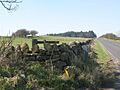
_Turret_22a_-_geograph.org.uk_-_1234724.jpg)
Turret 22A
Turret 22A (Portgate) is mostly buried under the Military Road, except for its south wall. This south wall is under a fence right next to the road and doesn't stick out into the field. When it was dug up in 1930, its stone walls were four layers high on the west side and three on the east. This turret was built in a style called "Standard A" construction. This suggests that a different group of builders worked on it compared to Milecastle 22.
In 1850, a stone was found nearby with the Latin words Latin: "Fulgar divom" carved into it. This means "the lightning of the gods." People think this stone was put up where lightning had struck the ground.
You can find Turret 22A on a map here: 55°00′47″N 2°01′31″W / 55.013139°N 2.025240°W
_Turret_22b_-_geograph.org.uk_-_1234730.jpg)
Turret 22B
Turret 22B (Stanley) was found in 1930. It's located next to the Military Road, about 10 yards (9.1 m) west of the lane that leads to Portgate Farm. Today, you can't see any remains of it because a modern road covers most of the site.
The vallum, which was a ditch and earthwork built alongside Hadrian's Wall, was very well preserved around Turret 22B. A historian named William Hutton wrote about how amazing it was:
I climbed over a stone wall to examine the wonder ... was fascinated, and unable to proceed; forgot I was on a wild common, a stranger, and the evening approaching ... lost in astonishment, I was not able to move at all.
You can find Turret 22B on a map here: 55°00′51″N 2°01′59″W / 55.014081°N 2.033184°W
Images for kids
-

The site of Milecastle 22
-
The site of Turret 22A
-
The site of Turret 22B
