Milecastle 23 facts for kids
Quick facts for kids Milecastle 23 |
|
|---|---|
| Northumberland, England, UK | |

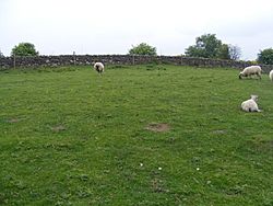
Site of Milecastle 23
|
|
|
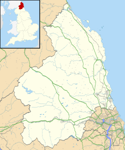
Location in Northumberland
|
|
| Coordinates | 55°00′54″N 2°02′25″W / 55.014932°N 2.040394°W |
Milecastle 23 (Stanley) was a small fort built by the Romans as part of Hadrian's Wall. This famous wall stretched across northern England. Milecastles were like mini-forts placed about every Roman mile along the wall.
Today, Milecastle 23 looks like a low, grassy bump in the ground. You can also see faint lines where a ditch used to be around it. It's found south of the B6318 Military Road, about 1.5 kilometers (1 mile) west of where it meets the A68 road.
Contents
Building Milecastle 23
Milecastle 23 was built in a special way, called a "long-axis milecastle." This means it was longer from north to south than from east to west. Historians think the Legio VI Victrix (Sixth Victorious Legion) built these types of milecastles. This Roman army group was based in Eboracum (modern-day York).
The milecastle was about 15.24 meters (50 feet) wide. Its east and west walls were "broad," meaning they were quite thick. The main Hadrian's Wall in this area was also built with broad, thick sections. We don't know how wide the south wall was.
Near the milecastle's north gate, the ditch around Hadrian's Wall changes slightly. There was also an 8-meter (26-foot) gap in the mound of earth next to the ditch. These features suggest there was once a path or "causeway" here. This causeway would have allowed people to cross the ditch easily. There was also evidence of a similar causeway across the vallum, which was a large ditch and mound system south of Hadrian's Wall.
Digging Up the Past: Investigations
Archaeologists and historians have studied Milecastle 23 over many years. They wanted to learn more about how it was built and used.
- 1930 - T. Hepple found the milecastle and figured out it was a long-axis type. He also noticed its broad east and west walls and the traces of the ditch.
- 1952 - Experts surveyed the vallum nearby. They found clues that a causeway might have been there in the past.
- 1966 - English Heritage, a group that looks after historic sites, investigated the area. They noted that the site was a mound about 1.2 meters (4 feet) high. Farming had spread out the mound over time. The old ditch was visible as a wide, shallow dip around the south, east, and west sides.
- 1989 - Another English Heritage investigation took place. They saw that the milecastle still existed as a platform up to 1 meter (3 feet) high. The ditch was shallow but could still be mapped on the south and east sides. They confirmed again that it was likely a long-axis milecastle.
Nearby Watchtowers: Associated Turrets
Every milecastle along Hadrian's Wall had two smaller watchtowers, called turrets. These turrets were placed about one-third and two-thirds of a Roman mile (about 0.5 to 1 kilometer) to the west of the milecastle. Soldiers from the milecastle would have guarded these turrets. The turrets connected to Milecastle 23 are known as Turret 23A and Turret 23B.
Turret 23A
You can't see any remains of Turret 23A (Stanley Plantation) on the surface today. Its location was figured out in 1920. However, its remains are now buried under the B6318 Military Road.
Location on Ordnance Survey map: 55°00′57″N 2°02′53″W / 55.015963°N 2.047949°W
Turret 23B
Like Turret 23A, there are no visible traces of Turret 23B (Wall Fell) on the surface. Its position was also found in 1920, based on where Turret 23A was. But its remains are also hidden beneath the B6318 Military Road, so it's hard to confirm its exact spot.
Location on Ordnance Survey map: 54°59′37″N 1°44′12″W / 54.993672°N 1.736733°W
Official Records
Historic sites like Milecastle 23 and its turrets are given special numbers for record-keeping. These numbers help archaeologists and historians track and study them.
| Monument | Monument Number | English Heritage Archive Number |
| Milecastle 23 | 18177 | NY 96 NE 8 |
| Turret 23A | 18180 | NY 96 NE 9 |
| Turret 23B | 18183 | NY 96 NE 10 |
Visiting the Site
You can visit the mound where Milecastle 23 once stood. It's located along the Hadrian's Wall Path National Trail. This trail is a popular walking route that follows the line of Hadrian's Wall.
 | Shirley Ann Jackson |
 | Garett Morgan |
 | J. Ernest Wilkins Jr. |
 | Elijah McCoy |


