Milecastle 24 facts for kids
Quick facts for kids Milecastle 24 |
|
|---|---|
| Northumberland, England, UK | |

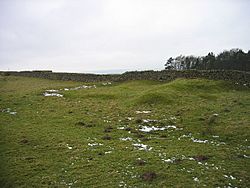
The low platform marking the remains of Milecastle 24
|
|
|
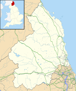
Location in Northumberland
|
|
| Coordinates | 55°01′04″N 2°03′47″W / 55.017825°N 2.063043°W |
Milecastle 24 (Wall Fell) was a small fort built by the Romans. It was an important part of Hadrian's Wall, a famous wall that stretched across northern England. Today, you can still see its remains as a low platform on the ground. It's located about 3 kilometers (1.9 miles) west of where the B6318 Military Road meets the A68.
Contents
Building Milecastle 24
Milecastle 24 was built in a similar way to Milecastle 23. This suggests it was a "long-axis milecastle," meaning it was longer from north to south.
The type of gate it had isn't known for sure. However, milecastles like this were often built by the Legio VI Victrix. This was a Roman army group (called a legion) based in a place called Eboracum, which is now the city of York.
The milecastle was about 15.24 meters (50 feet) wide. Its east and west walls were "broad," meaning they were quite thick. The main wall of Hadrian's Wall in this area was also built with this broad, thick style.
Some changes in the plants near the south gate suggest there might have been a path or bridge there once. This path might have been removed later.
Exploring the Past: Digs and Discoveries
People have studied Milecastle 24 over many years to learn more about it.
Early Visits and Finds
- 1879: A person named James Irwin Coates visited the milecastle. He drew pictures of what he saw.
- 1930: Experts figured out exactly where the milecastle was. They also learned details about how it was built.
Modern Investigations
- 1966: English Heritage, a group that looks after historic places, did an investigation. They confirmed where the milecastle was located. They noted that its outer wall was still there as a low, grassy bank, about 0.5 meters (1.6 feet) high. Some dirt from a nearby quarry partly covered it.
- 1989: English Heritage did another investigation. They found signs of old digging or "robber trenches," which were up to 0.3 meters (1 foot) deep. There was also a large pile of dirt, up to 1.2 meters (3.9 feet) high. Even with these changes, they confirmed the milecastle's location and its likely shape.
Helper Towers: Turrets 24A and 24B
Every milecastle along Hadrian's Wall had two smaller towers nearby. These towers are called turrets. They were placed about one-third and two-thirds of a Roman mile to the west of the milecastle. Soldiers from the milecastle would have guarded these turrets. The turrets connected to Milecastle 24 are called Turret 24A and Turret 24B.
Turret 24A: Green Field
Turret 24A (Green Field) is now hidden under the B6318 Military Road. It was dug up and studied in February 1930. The remains of its stone walls were found. They were three stone layers high on the northwest corner, but got lower towards the other corners.
You can find Turret 24A on a map at: 55°01′08″N 2°04′16″W / 55.018791°N 2.071083°W
Turret 24B: Tithe Barn
Turret 24B (Tithe Barn) is also located under the B6318 Military Road today. It was also excavated in February 1930. Like Turret 24A, its stone walls were three layers high on the northwest corner, getting lower towards the other corners.
You can find Turret 24B on a map at: 55°01′09″N 2°04′41″W / 55.019083°N 2.078152°W
Visiting Milecastle 24
You can visit the mound that marks Milecastle 24. It's located along the Hadrian's Wall Path National Trail, a popular walking route.
 | Delilah Pierce |
 | Gordon Parks |
 | Augusta Savage |
 | Charles Ethan Porter |


