
Milecastle 30 facts for kids
Quick facts for kids Milecastle 30 |
|
|---|---|
| Northumberland, England, UK | |

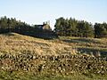
The site of Milecastle 30
|
|

Milecastle 30
Location in Northumberland
|
|
| Coordinates | 55°02′19″N 2°11′48″W / 55.038503°N 2.196562°W |
Milecastle 30 (Limestone Corner) was a small fort, called a milecastle, built by the Romans as part of Hadrian's Wall. Today, you can still see its remains as a raised area of earth, about 0.8 metres (2.6 ft) high. Some parts of the east wall are still standing. This section of wall is 3.1 metres (10 ft) long and 2.25 metres (7.4 ft) thick, reaching a height of 0.6 metres (2.0 ft). It's located at the western end of Limestone Corner, just off the B6318 Military Road.
Contents
Building Milecastle 30
Milecastle 30 was designed to be longer from north to south. We don't know much about its gates because they haven't been dug up yet. Roman armies, known as legions, likely built this milecastle. It might have been constructed by the legio VI Victrix from York (then called Eboracum) or the legio XX Valeria Victrix from Chester (then Deva Victrix).
The only known size for the milecastle, apart from the east wall, is its north-south length of 65.5 feet (20.0 m).
Discovering the Past
People have studied and dug at Milecastle 30 over the years to learn more about it.
- 1927 - FG Simpson visited the milecastle. He measured its north-south length and noticed the Military Way, a Roman road, nearby.
- 1951 - Digs uncovered the side walls and the main wall (called the curtain wall). They found that the main wall was built in a "narrow" style on "broad" foundations.
- 1965 - English Heritage investigated the site. They saw that the remains were a damaged raised area of earth. A 3.0-metre (9.8 ft) piece of the east wall was visible near the north-east corner. They also noted that the Military Way was clear to see as a raised path.
- 1989 - English Heritage did another study as part of the Hadrian's Wall Project. Their findings matched what was seen before.
Nearby Watchtowers
Every milecastle along Hadrian's Wall had two smaller watchtowers, called turrets, connected to it. These turrets were placed about one-third and two-thirds of a Roman mile to the west of the milecastle. Soldiers from the milecastle would have guarded these turrets. The turrets linked to Milecastle 30 are known as Turret 30A and Turret 30B.
Turret 30A
Turret 30A (Carrawburgh East) is mostly hidden under the B6138 Military Road. However, its south side was found in 1912, just south of the road. Its actual spot is about 40 metres (44 yd) west of where it was expected to be from Milecastle 30. This suggests the turrets might have been planned first, and Milecastle 30 was moved slightly to the top of Tuppermoor Hill.
Later digs in 1966 and English Heritage visits in 1965 and 1989 couldn't find the remains again.
You can find its location on a map here: 55°02′14″N 2°12′16″W / 55.037115°N 2.204441°W
_Turret_30b_on_Hadrian%27s_Wall_near_Carrawbrough_Farm_-_geograph.org.uk_-_1110724.jpg)
Turret 30B
Turret 30B (Carrawburgh West) appears as a 0.6-metre-high (2.0 ft) mound. It is about 40 metres (44 yd) west of the path leading to Carrawburgh Farm. The west wall of this turret was found in 1912. However, a 1966 excavation by RW Harris from Durham University didn't find clear results. Visits by English Heritage in 1966 and 1989 also didn't find much.
You can find its location on a map here: 55°02′11″N 2°12′44″W / 55.036473°N 2.212167°W
Visiting the Sites
Even though the milecastle is on private land, you can see its site over a wall next to the Hadrian's Wall Path National Trail.
You can't see anything left of Turrets 30A and 30B, but you can reach their locations from the B6318 Military Road.
Images for kids
-
The site of Turret 30B
