Milecastle 65 facts for kids
Quick facts for kids Milecastle 65 |
|
|---|---|
| Type | Milecastle |
| Location | |
| Coordinates | 54°54′45″N 2°55′27″W / 54.912602°N 2.924106°W |
| County | Cumbria |
| Country | England |
Milecastle 65 (Tarraby) was a small fort, known as a milecastle, that was part of Hadrian's Wall. Hadrian's Wall was a huge stone barrier built by the Romans across northern England to protect their land. Milecastles were like mini-forts placed about one Roman mile apart along the wall. They helped control who passed through and provided shelter for soldiers.
About Milecastle 65
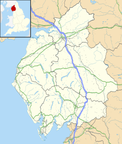
Milecastle 65 is located on a gentle slope facing west. It is about 150 meters (around 500 feet) southwest of a small village called Tarraby. This area is in the City of Carlisle district.
Today, you cannot see any parts of Milecastle 65 above ground. It is completely hidden underground. In the 1800s, people reportedly found a Roman altar (a stone used for religious offerings) and a sword near this spot.
South of the milecastle, you can still see a small part of the Vallum. The Vallum was a large ditch and earthwork built just south of Hadrian's Wall. It helped protect the wall from the Roman side. This part of the Vallum looks like a wide dip in the ground, about 10 meters (33 feet) wide and half a meter (1.6 feet) deep. It runs next to the B6264 road.
Exploring the Site
In 1976, archaeologists did a special study called a geophysical survey at Milecastle 65. This survey uses special equipment to look for things buried underground without digging. After the survey, they carried out a small excavation (careful digging) at the southwest corner of the milecastle.
During the excavation, they found at least two layers of the milecastle's original foundations. These foundations were the very bottom parts of the building. The geophysical survey also showed that the original cobble (stone) flooring inside the milecastle is still buried there. This tells us a lot about how the milecastle was built and what it looked like.
Nearby Turrets
Each milecastle along Hadrian's Wall had two smaller watchtowers, called turrets, connected to it. These turrets were usually placed about one-third and two-thirds of a Roman mile to the west of the milecastle. Soldiers from the milecastle would have guarded these turrets.
The turrets linked to Milecastle 65 are known as Turret 65A and Turret 65B. However, finding the exact spots of these turrets has been tricky. Many turrets between Milecastle 59 and Milecastle 72 were not found before 1961.
Turret 65A is thought to be about 250 meters (820 feet) east of a place called Beech Grove. Turret 65B is believed to be where the large Roman fort of Stanwix Roman Fort was built. It's likely that when the Stanwix fort was constructed, it replaced Turret 65B. In 1975, archaeologists dug at the expected location of Turret 65B but only found parts of a wall's core. This means we don't know if Turret 65B was replaced by the fort before or after the original "Turf Wall" (made of earth and turf) was replaced by the stronger "Stone Wall."
 | Jewel Prestage |
 | Ella Baker |
 | Fannie Lou Hamer |


