Mill Creek Ravine facts for kids
Quick facts for kids Mill Creek Ravine |
|
|---|---|

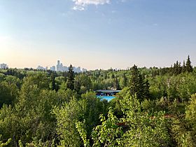
View of Mill Creek Ravine looking north, with the Mill Creek Pool in the foreground and downtown skyline in the background
|
|
| Country | Canada |
| Province | Alberta |
| Physical characteristics | |
| Main source | Alberta |
| River mouth | North Saskatchewan River 53°32′23″N 113°28′41″W / 53.53972°N 113.47806°W |
Mill Creek Ravine is a beautiful natural area located in Edmonton, Alberta, Canada. It's an important part of the River Valley parks and trail system. The ravine opens up into the North Saskatchewan River valley, close to the Cloverdale area and across from downtown Edmonton. It's a popular spot for outdoor fun!
Contents
Where Mill Creek Flows
The creek starts in small, wet areas called wetlands, which are south-east of a road called Anthony Henday Drive. From there, it flows north. Eventually, it reaches an exit point near 92 Avenue, between the neighborhoods of Strathcona and Bonnie Doon.
During the 1960s and 1970s, large parts of the creek were moved into underground pipes called culverts. This included a section that now runs under industrial areas in the city's south-east. The lower part of the creek was also moved into a tunnel and a concrete exit structure north of 88th Avenue.
This exit point can be seen on the east bank of the North Saskatchewan River, near 95 Avenue. You can easily spot it from the James MacDonald Bridge. The city is now thinking about bringing the creek back to the surface in some areas, a process called "daylighting." This would let the water flow naturally again.
A Look Back: Mill Creek's History
The creek got its name from a flour mill that was built there by William Bird in 1878.
The Old Railway Line
The ravine was once home to a railway line, part of the Edmonton, Yukon & Pacific Railway. This line ran from about 67 Avenue, crossed 99 Street, and went down into Mill Creek Ravine. It then continued through the ravine and over the Low Level Bridge.
The railway carried people and also served local businesses in the ravine. These included a brickyard, a coal mine, and two meat packing plants. A very large meat packing plant called Gainer's used to be on the western edge of the ravine, near 79 Avenue.
Most of the railway through the ravine was stopped in 1954. Only the part serving the meat packing plant stayed in use until about 1980.
From Rails to Trails
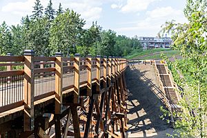
In the early 1980s, the City of Edmonton turned the old railway path into a paved bicycle path. This path is now a multi-use trail for walking, running, and biking. Four of the original wooden railway bridges, called trestles, are still used by the path.
The biggest of these, the Mill Creek Trestle at 76 Avenue, was recognized as an important historical site in 2004. The three smaller trestles were repaired and improved between 2017 and 2018. They added concrete supports and replaced some parts with new wooden pieces. The original wood was reused whenever possible. In 1988, the Edmonton Historical Board placed a sign in Mill Creek Park to remember the railway.
Protecting the Ravine
In the 1960s and 1970s, local people and nature lovers worked hard to stop the city from building a highway through the ravine. They were successful in protecting this beautiful natural space.
Fun Things to Do in the Ravine
The Mill Creek Outdoor Swimming Pool is located in the ravine at 8200 - 95A Street. It's a very popular place to cool off in the summer. Other fun places nearby include the Argyll Velodrome and BMX course, which is great for biking, and the Muttart Conservatory, which has amazing plants from all over the world.
Nearby Areas
Mill Creek Ravine is close to many Edmonton communities, including:
- Strathcona
- Bonnie Doon
- Ritchie
- King Edward Park
- Hazeldean
- Avonmore
- Argyll
- Greenview
- Jackson Heights
- Minchau
- Kiniski Gardens
- Wild Rose
- Silver Berry
- Tamarack
- Aster
 | Dorothy Vaughan |
 | Charles Henry Turner |
 | Hildrus Poindexter |
 | Henry Cecil McBay |


