
North Saskatchewan River valley parks system facts for kids
Quick facts for kids North Saskatchewan River valley parks system |
|
|---|---|
| Ribbon of Green, River Valley Parks | |

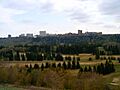
The North Saskatchewan River valley from William Hawrelak Park
|
|
| Type | Park system |
| Location | Edmonton Metropolitan Region, Alberta, Canada |
| Area | 7,300 hectares (18,000 acres) |
The North Saskatchewan River valley parks system is a huge collection of urban parks in the Edmonton Metropolitan Region of Alberta, Canada. It's also known as the Ribbon of Green or the River Valley Parks. These parks stretch along the North Saskatchewan River valley.
This amazing park system covers over 18,000 acres (7,300 hectares). That makes it the largest continuous area of urban parkland in Canada! It includes more than 30 provincial and city parks. These parks are located along the river from Devon to Fort Saskatchewan. Many of them are connected by trails.
People first suggested creating a large park along Edmonton's riverfront a long time ago. But the idea of a whole park system didn't really start until the late 1900s. In 1996, a group called the River Valley Alliance (RVA) was formed. Their job was to help develop this park system across the whole metropolitan area.
Most of the river valley is covered in grasslands, but some parts are forested. This area is home to many different kinds of plants and animals. It's also an important wildlife corridor, helping animals move safely through the region.
Contents
A Look Back: How the Park System Started
The North Saskatchewan River valley was shaped by glaciers long ago. For thousands of years, First Nations people used the river valley's resources. They might have even changed the valley a bit themselves. The plants in the valley changed a lot from the late 1700s to the 1900s. This was partly due to climate changes during the Little Ice Age.

When Métis and European farmers arrived, they brought new plants. They also cut down trees for lumber and let their animals graze in the valley. In the late 1800s and early 1900s, industries started to grow in the river valley. This happened after Fort Edmonton was built. People took resources from the valley to build and maintain the city of Edmonton.
The first brick-making and coal mining started in the 1840s. Later, dump sites, gravel pits, and lumber yards were built. By the 1900s, most of the valley's trees were gone. In the 1920s, Edmonton started getting resources from further away. This allowed the river valley's natural environment to start growing back.
By the 1920s, the river valley mostly had dumps, golf courses, and other low-impact developments. The last coal mine in the valley closed in 1970. In the mid-1900s, there were plans to build a highway through the valley. Work even started on it. But people didn't want a highway there, so the plan was stopped in 1974.
Creating the Park System

In 1907, a landscape architect named Frederick Todd suggested that Edmonton should use the river valley as a natural space. The city listened to his advice. Between 1907 and 1931, Edmonton bought over 100 properties in the river valley to turn into parkland. In 1915, the provincial government agreed to protect the river valley and its ravines for recreation.
In 1933, Edmonton passed a local law to protect the river valley as parkland. The city bought more private river valley properties from the 1950s to the 1970s. In 1970, another city law was passed. It defined the river valley and ravines and aimed to buy more land for parks.
After the highway plans were stopped in 1974, the provincial government created the Capital City Recreation Park. This park system included several river valley parks. During this time, small pieces of land were bought to connect the planned trail system. This connected parks like Hermitage Park and the High Level Bridge. The trails were later extended to other parks in West Edmonton. In 1976, the provincial government also put rules in place to limit building around the river valley from Devon to Fort Saskatchewan.
In 1985, Edmonton approved a plan that gave the river valley parks legal protection. It made the area an environmental protection zone for urban parks.
The idea to connect all the parks along the North Saskatchewan River in the Edmonton Metropolitan Region came about in the early 1990s. In 1996, a group of volunteers called the River Valley Alliance (RVA) was formed. This group included people from cities and counties along the river, like Devon, Edmonton, and Fort Saskatchewan. Their goal was to connect all the riverside parks into one big system. The RVA officially became an organization in 2003.
The RVA, along with the provincial and federal governments, created several plans for the park. These plans included ideas for trails and how to develop the park system. One plan in 2007 was a C$605-million project to develop a huge metropolitan park system.
Exploring the River Valley's Geography
.jpg)
The North Saskatchewan River valley park system stretches for about 88 kilometers (55 miles). It covers over 18,000 acres (7,300 hectares) of land. Most of the park system follows the North Saskatchewan River. This river flows northeast through the Edmonton Metropolitan Region and right through the center of Edmonton. The river's path has been changed a bit over time for things like dams and transportation.
The North Saskatchewan River valley is one of the few natural areas left in the region. Other parts of the metropolitan area have been built up with industries and cities. The river valley has changed because of human activity in the past. However, its deep and sloped shape helped limit how much it could be developed.
Most of the river valley is grasslands, but some parts are forested. There are 22 ravines connected to the river valley. In Edmonton, the river valley and its 14 ravines are very deep, about 100 to 150 meters (330 to 490 feet) deep. Sometimes, the soil on the slopes can move. In dry years, fires can happen.

Even though many parts of the river valley are public parks, some sections are privately owned. The RVA is still working to buy private land around the river valley. Their goal is to create a fully connected trail system. Some private facilities, like the EPCOR Utilities' Gold Bar Wastewater Treatment Plant, are in the river valley. Also, thousands of homes are located close to the river valley.
Many public parks and golf courses are found in the river valley. Besides being a great place for fun, the river valley also provides important natural services. It helps store carbon, controls erosion, and manages stormwater. It's estimated that the river valley provides services worth about C$350 million to $650 million to the region each year!
Parks in the Valley
The North Saskatchewan River Valley park system, including its ravines, has over 30 urban parks. Together, these parks form the largest city-run urban park and the biggest continuous urban parkland in Canada. The river valley itself has 3,556.4 hectares (8,788 acres) of dedicated parkland.
Several city parks and Strathcona Science Provincial Park are part of this system. Here are some of the city parks:
.jpg)
- Allan Stein Park
- Argyll Park
- Buena Vista Park
- Capilano Park
- Dawson Park
- Diamond Park
- Emily Murphy Park
- Floden Park
- Forest Heights Park
- Gallagher Park
- Gold Bar Park
- Goldstick Park
- Government House Park
- Henrietta Muir Edwards/Rafters Landing
- Hermitage Park
- Irene Parlby Park
- Kinnaird Park
- Kinsmen Park
- Louise McKinney Riverfront Park
- MacKinnon Ravine Park
- Mill Creek Ravine
- Nellie McClung Park
- Queen Elizabeth Park
- Rio Park
- Riverdale Park
- Rundle Park
- Sir Wilfrid Laurier Park
- Terwillegar Park
- Victoria Park
- Whitemud Park
- William Hawrelak Park
The parks in the river valley have the most washrooms and picnic sites compared to other city parks in Edmonton. Most of the parks have trails that connect them to other parts of the system. The river valley also has many fun facilities like baseball fields, dog parks, playgrounds, and tennis courts.
About 10 million people visit the river valley every year. This makes it the second most visited place in Alberta, after the West Edmonton Mall. However, some people worry that too many visitors and continued building might harm the local wildlife and the valley's long-term health.
Trails for Adventure

The river valley has over 160 kilometers (100 miles) of maintained trails that connect the parks. However, only about 90.6 kilometers (56.3 miles) of these trails are paved. Some parts of the trail network are not yet connected. The RVA plans to fully connect 75 kilometers (47 miles) of the trail system by 2024. In 2008, the city bought several hectares of private land to help "bridge the gaps" in the trail system.
The river itself is also used as a "water trail" for boats like canoes and kayaks. It's a key part of the park system. The river's flow changes throughout the year. It's not usually safe for swimming, but it's great for canoeing, kayaking, and rafting. The river flows across Alberta and Saskatchewan towards Lake Winnipeg and the Nelson River, eventually reaching Hudson's Bay.
Amazing Animals and Plants
The North Saskatchewan River valley is home to a wide variety of living things. While there isn't a complete list of all the animals and plants, we know a lot about them. It's estimated that there are at least 325 types of vascular plants, 50 types of mosses, and 40 types of lichen.
.jpg)
The valley is also home to about 150 bird species, 50 mammal species, 27 fish species, and seven amphibian and reptile species.
Historically, the river valley had many alder, balsam poplar, and willow trees. But most of these were cut down in the 1800s. Because of this, most of the trees you see today grew after 1900. Over time, new types of fruit, vegetables, shrubs, and trees were introduced to the area.
Today, the ravine slopes have many different plants like aspen, balsam poplar, white birch, and white spruce. The forests here are different from other regional forests because they have more black and white spruces. Other plants you might find include poison ivy and Saskatoon serviceberries. The area right along the river, called the riparian zone, is mostly wetlands with grass, sedges, and willows.
The river valley acts as a wildlife corridor. This means it's a safe path for animals to travel to other natural areas. Because of this, special wildlife crossings have been built where highways cross the valley.
Animals commonly found in the river valley include coyotes, great horned owls, lake sturgeons, North American porcupines, pileated woodpeckers, plains garter snakes, walleye, and white-tailed deer. Sometimes, cougars even make their way into Edmonton using this river valley system!
Images for kids
-
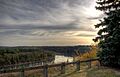
The North Saskatchewan River valley from William Hawrelak Park
-
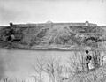
Fort Edmonton along the North Saskatchewan River, October 1870
-
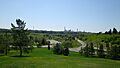
View of Rundle Park in May 2015
-
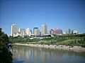
The North Saskatchewan River with downtown Edmonton in the background. The river cuts northeast through the city.
-
Victoria Golf Course, a city-run golf course in the river valley
-
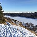
The North Saskatchewan River from Dawson Park, March 2017
-
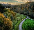
Paved trails at MacKinnon Ravine Park
-
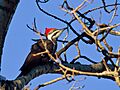
A pileated woodpecker in the North Saskatchewan River valley
