Mill Gap, Virginia facts for kids
Quick facts for kids
Mill Gap, Virginia
|
|
|---|---|
 |
|
| Country | United States |
| State | Virginia |
| County | Highland |
| Elevation | 2,533 ft (772 m) |
| Time zone | UTC-5 (Eastern (EST)) |
| • Summer (DST) | UTC-4 (EDT) |
| ZIP code |
24465
|
| Area code(s) | 540 |
| GNIS feature ID | 1497017 |
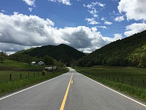
Mill Gap is a small, quiet village in Highland County, Virginia, United States. It is also known by other names like Green Hill, Millgap, or Rucksmanville. Mill Gap is an unincorporated community. This means it is a place where people live, but it doesn't have its own local government like a city or town. Instead, it is governed by the county.
About Mill Gap
Mill Gap is located in the beautiful state of Virginia. It is about 9.1 miles (14.6 kilometers) southwest of a larger town called Monterey, Virginia. You can find Mill Gap along Virginia State Route 84.
What is a Water Gap?
The community of Mill Gap is special because it is near something called a water gap. Imagine two mountains, Lantz Mountain and Little Mountain, standing tall. A water gap is like a natural doorway or a cut in these mountains. Through this opening, a stream or river, in this case, the East Back Creek, flows. It's how the creek finds its way through the mountains!
What You'll Find in Mill Gap
Mill Gap is a very small place. As of 2015, it mostly has a general store where people can buy everyday items. There is also a church for the community. A few homes are attached to these buildings. It's a peaceful rural village, meaning it's in the countryside, away from big cities.
 | Aaron Henry |
 | T. R. M. Howard |
 | Jesse Jackson |


