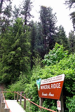
Mineral Ridge National Recreation Trail facts for kids
Quick facts for kids Mineral Ridge National Recreation Trail, Idaho |
|
|---|---|

Trailhead
|
|
| Length | 3.3 mi (5.3 km) |
| Location | Kootenai County, Idaho, United States |
| Designation | National Recreation Trail |
| Use | Hiking, Outdoor education |
| Elevation change | 600 ft (180 m) |
| Highest point | Summit of Mineral Ridge, 2,400 ft (730 m) |
| Lowest point | Parking lot of the trail |
| Difficulty | Trail grade is an average of 8%, with a 15% maximum |
| Season | Year round access |
| Sights | Beauty Bay on Lake Coeur d'Alene |
The Mineral Ridge National Recreation Trail is a fantastic place for a hike in the beautiful outdoors. It's located near Lake Coeur d'Alene in Kootenai County, Idaho, United States. This trail is managed by the Bureau of Land Management (BLM), which is a government agency that takes care of public lands.
Work on the trail began in 1963, making it a well-established path. In 1982, it received a special title: a National Recreation Trail. This means it's recognized as a great place for outdoor fun and learning. As you walk the 3.3-mile (5.3 km) trail, you can follow a self-guided tour that teaches you about the area.
Contents
Exploring the Mineral Ridge Trail
This trail offers a wonderful adventure for hikers of different skill levels. It's a great way to connect with nature and learn about the local environment.
What Makes This Trail Special?
The Mineral Ridge Trail is known for its amazing views and educational opportunities. It's designed to be a place where people can enjoy hiking while also learning about the plants, animals, and history of the area.
Views and Scenery
One of the best parts of hiking this trail is the stunning scenery. You'll get incredible views of Beauty Bay on Lake Coeur d'Alene. The lake itself is a large, beautiful body of water surrounded by forests and mountains. The trail climbs up to the summit of Mineral Ridge, which is about 2,400 feet high. From there, you can see far across the landscape.
Trail Difficulty and Elevation
The trail is considered moderately difficult. It has an average slope of 8%, meaning it goes uphill gradually. However, some parts can be steeper, reaching a maximum slope of 15%. The trail gains about 600 feet in elevation from the parking lot to the summit. This makes it a good workout, but it's manageable for most hikers aged 12-15.
When to Visit the Trail
You can visit the Mineral Ridge National Recreation Trail at any time of the year! It's open year-round, which means you can experience its beauty in every season. Whether you prefer the green leaves of summer, the colorful changes of autumn, or even a snowy winter hike, the trail is ready for you.
Plants and Trees Along the Trail
The forests around the Mineral Ridge Trail are home to several types of trees and plants. They create a beautiful green environment and provide homes for many animals.
Common Trees You'll See
The two most common types of trees you'll find along the trail are:
- Ponderosa Pine: These are tall trees with long needles and reddish-brown bark that looks like puzzle pieces. They are very common in the western United States.
- Douglas Fir: These trees have soft, flat needles and cones that hang down. They are also very tall and are an important part of the forest ecosystem.
These trees provide shade for hikers and are a vital part of the local habitat. They help keep the air clean and support a variety of wildlife.
Learning on the Trail
The Mineral Ridge Trail is not just for hiking; it's also a place for Outdoor education. The self-guided interpretive tour means there are signs or markers along the path that explain interesting facts about the nature and history around you. This makes your hike a learning adventure!

