
Misquamicut, Rhode Island facts for kids
Quick facts for kids
Misquamicut, Rhode Island
|
|
|---|---|
.jpg)
Andrea Hotel, c.1930s
|
|

Misquamicut, Rhode Island
Location in Rhode Island

Misquamicut, Rhode Island
Location in the United States
|
|
| Country | United States |
| State | Rhode Island |
| County | Washington |
| Area | |
| • Total | 1.25 sq mi (3.23 km2) |
| • Land | 1.17 sq mi (3.04 km2) |
| • Water | 0.07 sq mi (0.19 km2) |
| Elevation | 3 ft (1 m) |
| Population
(2020)
|
|
| • Total | 434 |
| • Density | 369.99/sq mi (142.89/km2) |
| Time zone | UTC-5 (Eastern (EST)) |
| • Summer (DST) | UTC-4 (EDT) |
| ZIP code |
02891
|
| Area code(s) | 401 |
| FIPS code | 44-46000 |
| GNIS feature ID | 1217591 |
Misquamicut (pronounced MISS-kwahm-eh-kut) is a small community located in southern Washington County, Rhode Island. It is part of the larger town of Westerly. In 2020, about 434 people lived there. Misquamicut is known for its beautiful beaches and is a popular spot for visitors.
Contents
What's in a Name?
The name Misquamicut comes from the Narragansett language. It means "Red Fish Place" or "Salmon Place." This suggests that the area was once rich in these types of fish.
Misquamicut's History
Misquamicut was first known as Pleasant View. The land was bought from Chief Sosoa of the Montauks in 1661. The name changed to Misquamicut in 1928.
The area has faced tough times due to powerful storms. Major hurricanes hit in 1938, 1944, and 1954. These storms destroyed many beach homes, hotels, and other buildings. After these events, a part of the oceanfront became Misquamicut State Beach in 1959. This is now a public beach for everyone to enjoy.
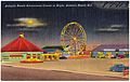
Atlantic Beach Park
Atlantic Beach Park is a fun amusement center in Misquamicut. It covers about 12 acres of land. This park is located near Misquamicut State Beach. It is also close to Winnapaug Pond, where people find tasty Rhode Island quahogs and bay scallops.
The park used to be called "Atlantic Beach Casino." It still has a classic carousel with an old-fashioned band organ. You can also find rides, bumper cars, a game room, and an ice cream stand. More recently, they've added miniature golf, go-carts, a batting cage, water slides, and a gift shop. It's a great place for families to have fun!
Geography of Misquamicut
Misquamicut covers a total area of about 1.25 square miles (3.23 square kilometers). Most of this area is land, about 1.17 square miles (3.04 square kilometers). The rest, about 0.075 square miles (0.19 square kilometers), is water.
People of Misquamicut
| Historical population | |||
|---|---|---|---|
| Census | Pop. | %± | |
| 2010 | 390 | — | |
| 2020 | 434 | 11.3% | |
| U.S. Decennial Census | |||
In 2020, the population of Misquamicut was 434 people. Most residents are white or European American. A small number of people are Native American or Asian. About 1.15% of the population identifies as Hispanic or Latino.
The community has a mix of families and individuals. Many households consist of single people, and a good number of residents are 65 years or older. The average age in Misquamicut is about 63.7 years.
Many people in Misquamicut have Italian, Irish, English, or German backgrounds. Other ancestries include Polish, French, and Scottish.
Images for kids
-
1940s postcard showing Atlantic Beach Amusement Center at night.
.jpg)
See also
 In Spanish: Misquamicut (Rhode Island) para niños
